Mountain House geodata
Mountain House (California) is a populated place; located in United States in America/Los_Angeles (GMT-7) time zone. With population of 9,675 people, there are 4562 cities with bigger population in this country. Compared to other cities in United States, 62.7% of cities are located further ↑North; 94.4% of cities are located further →East and 90.5% of cities have higher elevation than Mountain House. Note1


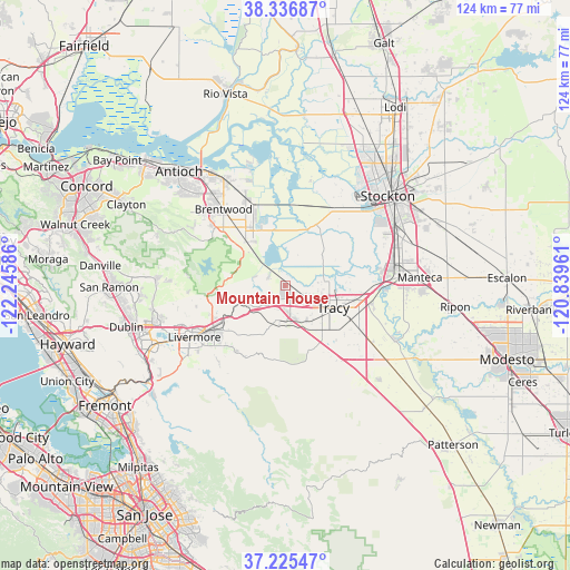
Mountain House GPS coordinates[2]
37° 46' 59.736" North, 121° 32' 33.828" West
| Map corner | latitude | longitude |
|---|---|---|
| Upper-left | 38.33687°, | -122.24586° |
| Center: | 37.78326°, | -121.54273° |
| Lower-right: | 37.22547°, | -120.83961° |
| Map W x H: | 123.6×123.6 km | = 76.8×76.8mi |
| max Lat: | 71.29058° ⇑62.7% North |
| Mountain House: | 37.78326° |
| min Lat: | ⇓37.3% South 19.06759° |
| min Long | Mountain House | max Long |
| -171.73463° | -121.54273° | -66.98998° |
| W 5.6%⇐ | ⇒94.4% E |
Elevation
Elevation of Mountain House is 15 m = 49 ft, and this is 279.8 m = 918 ft below average elevation for this country.
| Max E: |
3189 m = 10463 ft | 90.5% |
| Avg. | 294.8 m = 967 ft | |
| Mountain House | 15 m = 49 ft | |
Min E: |
-60 m = -197 ft | 9.5% |
See also: United States elevation on elevation.city.
Geographical zone
Mountain House is located in North temperate zone (between Tropic of Cancer and the Arctic Circle). Distance of this Northern Tropic circle is 1595.2 km =991.2 mi to South.| Distance of | km | miles | from Mountain House |
|---|---|---|---|
| North Pole | 5806 | 3607.7 | to North |
| Arctic Circle | 3200.1 | 1988.4 | to North |
| Tropic Cancer | 1595.2 | 991.2 | to South |
| Equator | 4201.1 | 2610.4 | to South |


Nearby cities:
15 places around Mountain House: (largest is in red/bold)
• Bethel Island
27.1 km =16.8 mi,  341°
341°
• Brentwood
21.3 km =13.2 mi,  320°
320°
• Byron
12.5 km =7.8 mi, 318°
• Country Club
27.2 km =16.9 mi,  40°
40°
• Discovery Bay
14.8 km =9.2 mi, 340°
• French Camp
26.4 km =16.4 mi,  64°
64°
• Kennedy
30.2 km =18.8 mi, 57°
• Knightsen
23.4 km =14.5 mi,  331°
331°
• Lathrop
23.8 km =14.8 mi,  79°
79°
• Livermore
22.8 km =14.2 mi,  240°
240°
• Manteca
28.7 km =17.8 mi,  86°
86°
• Oakley
28.1 km =17.5 mi, 327°
• Stockton
29.4 km =18.3 mi,  48°
48°
• Taft Mosswood
27 km =16.8 mi, 57°
• Tracy
11.3 km =7 mi,  115°
115°
Sources, notices
• [Note1] Compared only with cities in United States existing in our database
• [Src1] Map data: © OpenStreetMap contributors (CC-BY-SA)
• [Src2] Other city data from geonames.org with taken over terms of usage.
• [Src3] Geographical zone / Annual Mean Temperature by Robert A. Rohde @ Wikipedia
