Pleasanton geodata
Pleasanton (California) is a populated place; located in United States in America/Los_Angeles (GMT-7) time zone. With population of 79,510 people, there are 500 cities with bigger population in this country. Compared to other cities in United States, 63.4% of cities are located further ↑North; 94.8% of cities are located further →East and 68.9% of cities have higher elevation than Pleasanton. Note1


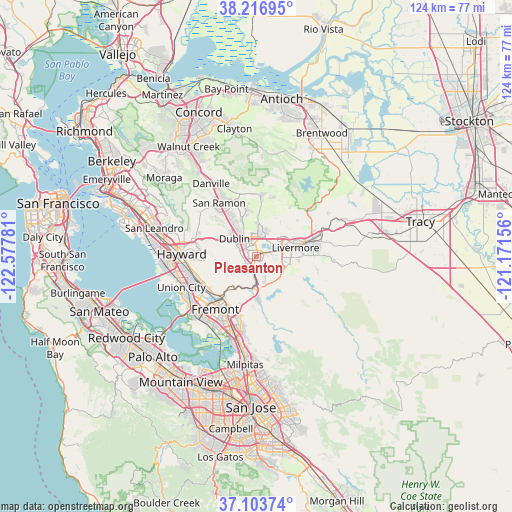
Pleasanton GPS coordinates[2]
37° 39' 44.748" North, 121° 52' 28.848" West
| Map corner | latitude | longitude |
|---|---|---|
| Upper-left | 38.21695°, | -122.57781° |
| Center: | 37.66243°, | -121.87468° |
| Lower-right: | 37.10374°, | -121.17156° |
| Map W x H: | 123.8×123.8 km | = 76.9×76.9mi |
| max Lat: | 71.29058° ⇑63.4% North |
| Pleasanton: | 37.66243° |
| min Lat: | ⇓36.6% South 19.06759° |
| min Long | Pleasanton | max Long |
| -171.73463° | -121.87468° | -66.98998° |
| W 5.2%⇐ | ⇒94.8% E |
Elevation
Elevation of Pleasanton is 107 m = 351 ft, and this is 187.8 m = 616 ft below average elevation for this country.
| Max E: |
3189 m = 10463 ft | 68.9% |
| Avg. | 294.8 m = 967 ft | |
| Pleasanton | 107 m = 351 ft | |
Min E: |
-60 m = -197 ft | 31.1% |
See also: Pleasanton elevation on elevation.city.
Geographical zone
Pleasanton is located in North temperate zone (between Tropic of Cancer and the Arctic Circle). Distance of this Northern Tropic circle is 1581.8 km =982.9 mi to South.| Distance of | km | miles | from Pleasanton |
|---|---|---|---|
| North Pole | 5819.4 | 3616 | to North |
| Arctic Circle | 3213.5 | 1996.8 | to North |
| Tropic Cancer | 1581.8 | 982.9 | to South |
| Equator | 4187.7 | 2602.1 | to South |


Nearby cities:
15 places around Pleasanton: (largest is in red/bold)
• Ashland
21.3 km =13.2 mi,  279°
279°
• Blackhawk
17.8 km =11.1 mi,  350°
350°
• Castro Valley
19 km =11.8 mi, 280°
• Cherryland
20.2 km =12.6 mi, 275°
• Danville
20.8 km =12.9 mi,  328°
328°
• Diablo
20.5 km =12.7 mi,  339°
339°
• Dublin
7 km =4.3 mi,  309°
309°
• Fairview
15.2 km =9.4 mi, 276°
• Fremont
16.2 km =10.1 mi,  218°
218°
• Hayward
18.2 km =11.3 mi,  272°
272°
• Livermore
9.6 km =6 mi,  77°
77°
• Newark
20.8 km =12.9 mi, 224°
• San Ramon
15.9 km =9.9 mi, 325°
• Sunol
7.7 km =4.8 mi,  189°
189°
• Union City
14.7 km =9.1 mi,  239°
239°
Sources, notices
• [Note1] Compared only with cities in United States existing in our database
• [Src1] Map data: © OpenStreetMap contributors (CC-BY-SA)
• [Src2] Other city data from geonames.org with taken over terms of usage.
• [Src3] Geographical zone / Annual Mean Temperature by Robert A. Rohde @ Wikipedia
