Rubidoux geodata
Rubidoux (California) is a populated place; located in United States in America/Los_Angeles (GMT-7) time zone. With population of 34,280 people, there are 1436 cities with bigger population in this country. Compared to other cities in United States, 80.3% of cities are located further ↑North; 90.3% of cities are located further →East and 59.1% of cities have lower elevation than Rubidoux. Note1


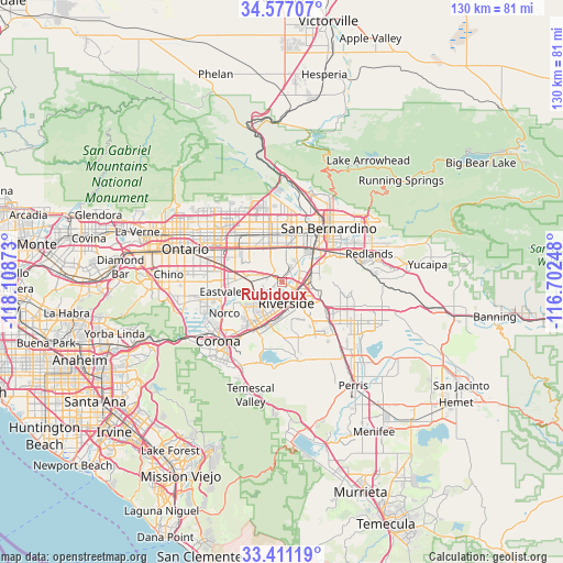
Rubidoux GPS coordinates[2]
33° 59' 46.068" North, 117° 24' 20.16" West
| Map corner | latitude | longitude |
|---|---|---|
| Upper-left | 34.57707°, | -118.10873° |
| Center: | 33.99613°, | -117.4056° |
| Lower-right: | 33.41119°, | -116.70248° |
| Map W x H: | 129.6×129.6 km | = 80.5×80.5mi |
| max Lat: | 71.29058° ⇑80.3% North |
| Rubidoux: | 33.99613° |
| min Lat: | ⇓19.7% South 19.06759° |
| min Long | Rubidoux | max Long |
| -171.73463° | -117.4056° | -66.98998° |
| W 9.7%⇐ | ⇒90.3% E |
Elevation
Elevation of Rubidoux is 236 m = 774 ft, and this is 58.8 m = 193 ft below average elevation for this country.
| Max E: |
3189 m = 10463 ft | 40.9% |
| Avg. | 294.8 m = 967 ft | |
| Rubidoux | 236 m = 774 ft | |
Min E: |
-60 m = -197 ft | 59.1% |
See also: United States elevation on elevation.city.
Geographical zone
Rubidoux is located in North temperate zone (between Tropic of Cancer and the Arctic Circle). Distance of this Northern Tropic circle is 1174.1 km =729.6 mi to South.| Distance of | km | miles | from Rubidoux |
|---|---|---|---|
| North Pole | 6227 | 3869.3 | to North |
| Arctic Circle | 3621.2 | 2250.1 | to North |
| Tropic Cancer | 1174.1 | 729.6 | to South |
| Equator | 3780 | 2348.8 | to South |


Nearby cities:
15 places around Rubidoux: (largest is in red/bold)
• Bloomington
8.3 km =5.2 mi,  6°
6°
• Colton
12.1 km =7.5 mi,  44°
44°
• Eastvale
15.1 km =9.4 mi,  256°
256°
• Fontana
11 km =6.8 mi,  345°
345°
• Glen Avon
7.5 km =4.7 mi,  283°
283°
• Grand Terrace
9.5 km =5.9 mi,  63°
63°
• Highgrove
7 km =4.3 mi,  71°
71°
• Jurupa Valley
10.2 km =6.3 mi,  267°
267°
• Loma Linda
14.5 km =9 mi, 66°
• Norco
15 km =9.3 mi,  241°
241°
• Pedley
6.9 km =4.3 mi,  250°
250°
• Rialto
12.7 km =7.9 mi, 14°
• Riverside
4.8 km =3 mi,  169°
169°
• Sunnyslope
3.1 km =1.9 mi,  304°
304°
• Woodcrest
13.4 km =8.3 mi,  160°
160°
Sources, notices
• [Note1] Compared only with cities in United States existing in our database
• [Src1] Map data: © OpenStreetMap contributors (CC-BY-SA)
• [Src2] Other city data from geonames.org with taken over terms of usage.
• [Src3] Geographical zone / Annual Mean Temperature by Robert A. Rohde @ Wikipedia
