Woodcrest geodata
Woodcrest (California) is a populated place; located in United States in America/Los_Angeles (GMT-7) time zone. With population of 14,347 people, there are 3369 cities with bigger population in this country. Compared to other cities in United States, 81.1% of cities are located further ↑North; 90.3% of cities are located further →East and 87.1% of cities have lower elevation than Woodcrest. Note1


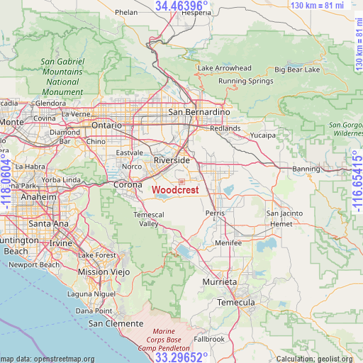
Woodcrest GPS coordinates[2]
33° 52' 56.064" North, 117° 21' 26.172" West
| Map corner | latitude | longitude |
|---|---|---|
| Upper-left | 34.46396°, | -118.0604° |
| Center: | 33.88224°, | -117.35727° |
| Lower-right: | 33.29652°, | -116.65415° |
| Map W x H: | 129.8×129.8 km | = 80.7×80.7mi |
| max Lat: | 71.29058° ⇑81.1% North |
| Woodcrest: | 33.88224° |
| min Lat: | ⇓18.9% South 19.06759° |
| min Long | Woodcrest | max Long |
| -171.73463° | -117.35727° | -66.98998° |
| W 9.7%⇐ | ⇒90.3% E |
Elevation
Elevation of Woodcrest is 470 m = 1542 ft, and this is 175.2 m = 575 ft above average elevation for this country.
| Max E: |
3189 m = 10463 ft | 12.9% |
| Woodcrest | 470 m 1542 ft | |
| Avg. | 294.8 m = 967 ft | |
Min E: |
-60 m = -197 ft | 87.1% |
See also: United States elevation on elevation.city.
Geographical zone
Woodcrest is located in North temperate zone (between Tropic of Cancer and the Arctic Circle). Distance of this Northern Tropic circle is 1161.4 km =721.7 mi to South.| Distance of | km | miles | from Woodcrest |
|---|---|---|---|
| North Pole | 6239.7 | 3877.2 | to North |
| Arctic Circle | 3633.8 | 2257.9 | to North |
| Tropic Cancer | 1161.4 | 721.7 | to South |
| Equator | 3767.4 | 2341 | to South |


Nearby cities:
15 places around Woodcrest: (largest is in red/bold)
• El Cerrito Corona
16 km =9.9 mi,  253°
253°
• Good Hope
15.5 km =9.6 mi,  147°
147°
• Grand Terrace
17.3 km =10.7 mi,  13°
13°
• Highgrove
15 km =9.3 mi, 8°
• Home Gardens
15.1 km =9.4 mi,  268°
268°
• March Air Force Base
8.8 km =5.5 mi,  82°
82°
• Mead Valley
7.8 km =4.8 mi,  133°
133°
• Meadowbrook
18.6 km =11.6 mi,  159°
159°
• Moreno Valley
13.2 km =8.2 mi,  62°
62°
• Norco
18.5 km =11.5 mi,  287°
287°
• Pedley
15.1 km =9.4 mi,  313°
313°
• Perris
16.3 km =10.1 mi, 133°
• Riverside
8.7 km =5.4 mi,  335°
335°
• Rubidoux
13.4 km =8.3 mi, 340°
• Sunnyslope
16 km =9.9 mi,  334°
334°
Sources, notices
• [Note1] Compared only with cities in United States existing in our database
• [Src1] Map data: © OpenStreetMap contributors (CC-BY-SA)
• [Src2] Other city data from geonames.org with taken over terms of usage.
• [Src3] Geographical zone / Annual Mean Temperature by Robert A. Rohde @ Wikipedia
