Eastvale geodata
Eastvale (California) is a populated place; located in United States in America/Los_Angeles (GMT-7) time zone. With population of 59,039 people, there are 767 cities with bigger population in this country. Compared to other cities in United States, 80.5% of cities are located further ↑North; 90.4% of cities are located further →East and 51.9% of cities have higher elevation than Eastvale. Note1


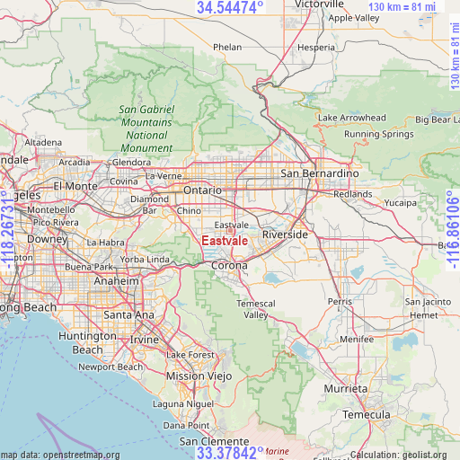
Eastvale GPS coordinates[2]
33° 57' 48.888" North, 117° 33' 51.048" West
| Map corner | latitude | longitude |
|---|---|---|
| Upper-left | 34.54474°, | -118.26731° |
| Center: | 33.96358°, | -117.56418° |
| Lower-right: | 33.37842°, | -116.86106° |
| Map W x H: | 129.7×129.7 km | = 80.6×80.6mi |
| max Lat: | 71.29058° ⇑80.5% North |
| Eastvale: | 33.96358° |
| min Lat: | ⇓19.5% South 19.06759° |
| min Long | Eastvale | max Long |
| -171.73463° | -117.56418° | -66.98998° |
| W 9.6%⇐ | ⇒90.4% E |
Elevation
Elevation of Eastvale is 191 m = 627 ft, and this is 103.8 m = 341 ft below average elevation for this country.
| Max E: |
3189 m = 10463 ft | 51.9% |
| Avg. | 294.8 m = 967 ft | |
| Eastvale | 191 m = 627 ft | |
Min E: |
-60 m = -197 ft | 48.1% |
See also: Eastvale elevation on elevation.city.
Geographical zone
Eastvale is located in North temperate zone (between Tropic of Cancer and the Arctic Circle). Distance of this Northern Tropic circle is 1170.5 km =727.3 mi to South.| Distance of | km | miles | from Eastvale |
|---|---|---|---|
| North Pole | 6230.7 | 3871.6 | to North |
| Arctic Circle | 3624.8 | 2252.3 | to North |
| Tropic Cancer | 1170.5 | 727.3 | to South |
| Equator | 3776.4 | 2346.5 | to South |


Nearby cities:
15 places around Eastvale: (largest is in red/bold)
• Chino
12.7 km =7.9 mi,  295°
295°
• Corona
9.8 km =6.1 mi,  181°
181°
• El Cerrito Corona
14.2 km =8.8 mi,  164°
164°
• Glen Avon
9.1 km =5.7 mi,  53°
53°
• Home Gardens
10.3 km =6.4 mi, 157°
• Jurupa Valley
5.5 km =3.4 mi, 53°
• Los Serranos
13.3 km =8.3 mi,  274°
274°
• Norco
3.9 km =2.4 mi, 158°
• Ontario
13.7 km =8.5 mi,  324°
324°
• Pedley
8.2 km =5.1 mi,  80°
80°
• Rancho Cucamonga
16.1 km =10 mi,  350°
350°
• Riverside
15.5 km =9.6 mi,  94°
94°
• Rubidoux
15.1 km =9.4 mi, 76°
• Sunnyslope
13.2 km =8.2 mi,  65°
65°
• Upland
16.8 km =10.4 mi,  332°
332°
Sources, notices
• [Note1] Compared only with cities in United States existing in our database
• [Src1] Map data: © OpenStreetMap contributors (CC-BY-SA)
• [Src2] Other city data from geonames.org with taken over terms of usage.
• [Src3] Geographical zone / Annual Mean Temperature by Robert A. Rohde @ Wikipedia
