Pedley geodata
Pedley (California) is a populated place; located in United States in America/Los_Angeles (GMT-7) time zone. With population of 12,672 people, there are 3737 cities with bigger population in this country. Compared to other cities in United States, 80.4% of cities are located further ↑North; 90.3% of cities are located further →East and 55.8% of cities have lower elevation than Pedley. Note1


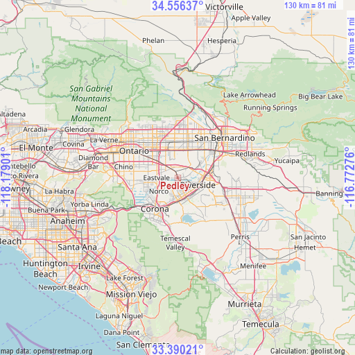
Pedley GPS coordinates[2]
33° 58' 31.044" North, 117° 28' 33.168" West
| Map corner | latitude | longitude |
|---|---|---|
| Upper-left | 34.55637°, | -118.17901° |
| Center: | 33.97529°, | -117.47588° |
| Lower-right: | 33.39021°, | -116.77276° |
| Map W x H: | 129.7×129.7 km | = 80.6×80.6mi |
| max Lat: | 71.29058° ⇑80.4% North |
| Pedley: | 33.97529° |
| min Lat: | ⇓19.6% South 19.06759° |
| min Long | Pedley | max Long |
| -171.73463° | -117.47588° | -66.98998° |
| W 9.7%⇐ | ⇒90.3% E |
Elevation
Elevation of Pedley is 222 m = 728 ft, and this is 72.8 m = 239 ft below average elevation for this country.
| Max E: |
3189 m = 10463 ft | 44.2% |
| Avg. | 294.8 m = 967 ft | |
| Pedley | 222 m = 728 ft | |
Min E: |
-60 m = -197 ft | 55.8% |
See also: United States elevation on elevation.city.
Geographical zone
Pedley is located in North temperate zone (between Tropic of Cancer and the Arctic Circle). Distance of this Northern Tropic circle is 1171.8 km =728.1 mi to South.| Distance of | km | miles | from Pedley |
|---|---|---|---|
| North Pole | 6229.4 | 3870.8 | to North |
| Arctic Circle | 3623.5 | 2251.5 | to North |
| Tropic Cancer | 1171.8 | 728.1 | to South |
| Equator | 3777.7 | 2347.4 | to South |


Nearby cities:
15 places around Pedley: (largest is in red/bold)
• Bloomington
12.9 km =8 mi,  34°
34°
• Corona
13.9 km =8.6 mi,  216°
216°
• Eastvale
8.2 km =5.1 mi,  260°
260°
• El Cerrito Corona
15.6 km =9.7 mi,  196°
196°
• Fontana
13.5 km =8.4 mi,  16°
16°
• Glen Avon
4.1 km =2.5 mi,  348°
348°
• Grand Terrace
16.3 km =10.1 mi,  66°
66°
• Highgrove
13.9 km =8.6 mi, 71°
• Home Gardens
11.6 km =7.2 mi, 201°
• Jurupa Valley
4.2 km =2.6 mi,  297°
297°
• Norco
8.3 km =5.2 mi,  233°
233°
• Riverside
7.7 km =4.8 mi,  108°
108°
• Rubidoux
6.9 km =4.3 mi, 70°
• Sunnyslope
5.7 km =3.5 mi,  43°
43°
• Woodcrest
15.1 km =9.4 mi,  133°
133°
Sources, notices
• [Note1] Compared only with cities in United States existing in our database
• [Src1] Map data: © OpenStreetMap contributors (CC-BY-SA)
• [Src2] Other city data from geonames.org with taken over terms of usage.
• [Src3] Geographical zone / Annual Mean Temperature by Robert A. Rohde @ Wikipedia
