Riverside geodata
Riverside (California) is a seat of a second-order administrative division; located in United States in America/Los_Angeles (GMT-7) time zone. With population of 322,424 people, there are 65 cities with bigger population in this country. Compared to other cities in United States, 80.6% of cities are located further ↑North; 90.3% of cities are located further →East and 63.9% of cities have lower elevation than Riverside. Note1


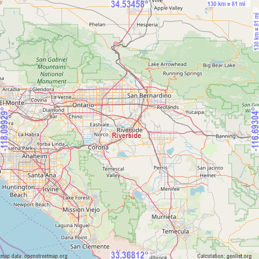
Riverside GPS coordinates[2]
33° 57' 12.06" North, 117° 23' 46.176" West
| Map corner | latitude | longitude |
|---|---|---|
| Upper-left | 34.53458°, | -118.09929° |
| Center: | 33.95335°, | -117.39616° |
| Lower-right: | 33.36812°, | -116.69304° |
| Map W x H: | 129.7×129.7 km | = 80.6×80.6mi |
| max Lat: | 71.29058° ⇑80.6% North |
| Riverside: | 33.95335° |
| min Lat: | ⇓19.4% South 19.06759° |
| min Long | Riverside | max Long |
| -171.73463° | -117.39616° | -66.98998° |
| W 9.7%⇐ | ⇒90.3% E |
Elevation
Elevation of Riverside is 257 m = 843 ft, and this is 37.8 m = 124 ft below average elevation for this country.
| Max E: |
3189 m = 10463 ft | 36.1% |
| Avg. | 294.8 m = 967 ft | |
| Riverside | 257 m = 843 ft | |
Min E: |
-60 m = -197 ft | 63.9% |
See also: Riverside elevation on elevation.city.
Geographical zone
Riverside is located in North temperate zone (between Tropic of Cancer and the Arctic Circle). Distance of this Northern Tropic circle is 1169.3 km =726.6 mi to South.| Distance of | km | miles | from Riverside |
|---|---|---|---|
| North Pole | 6231.8 | 3872.3 | to North |
| Arctic Circle | 3625.9 | 2253 | to North |
| Tropic Cancer | 1169.3 | 726.6 | to South |
| Equator | 3775.3 | 2345.9 | to South |


Nearby cities:
15 places around Riverside: (largest is in red/bold)
• Bloomington
13 km =8.1 mi,  0°
0°
• Colton
15.4 km =9.6 mi,  29°
29°
• Eastvale
15.5 km =9.6 mi,  274°
274°
• Glen Avon
10.4 km =6.5 mi,  308°
308°
• Grand Terrace
11.8 km =7.3 mi,  40°
40°
• Highgrove
9 km =5.6 mi, 39°
• Home Gardens
14.2 km =8.8 mi,  233°
233°
• Jurupa Valley
11.9 km =7.4 mi,  291°
291°
• March Air Force Base
14 km =8.7 mi,  119°
119°
• Moreno Valley
15.4 km =9.6 mi,  96°
96°
• Norco
14.3 km =8.9 mi,  260°
260°
• Pedley
7.7 km =4.8 mi, 288°
• Rubidoux
4.8 km =3 mi,  349°
349°
• Sunnyslope
7.4 km =4.6 mi,  332°
332°
• Woodcrest
8.7 km =5.4 mi,  155°
155°
Sources, notices
• [Note1] Compared only with cities in United States existing in our database
• [Src1] Map data: © OpenStreetMap contributors (CC-BY-SA)
• [Src2] Other city data from geonames.org with taken over terms of usage.
• [Src3] Geographical zone / Annual Mean Temperature by Robert A. Rohde @ Wikipedia
