Del Rey geodata
Del Rey (California) is a populated place; located in United States in America/Los_Angeles (GMT-7) time zone. With population of 1,639 people, there are 13128 cities with bigger population in this country. Compared to other cities in United States, 67.5% of cities are located further ↑North; 92.5% of cities are located further →East and 69.2% of cities have higher elevation than Del Rey. Note1


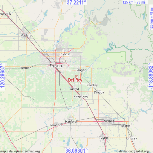
Del Rey GPS coordinates[2]
36° 39' 32.832" North, 119° 35' 37.464" West
| Map corner | latitude | longitude |
|---|---|---|
| Upper-left | 37.2211°, | -120.29687° |
| Center: | 36.65912°, | -119.59374° |
| Lower-right: | 36.09301°, | -118.89062° |
| Map W x H: | 125.4×125.4 km | = 77.9×77.9mi |
| max Lat: | 71.29058° ⇑67.5% North |
| Del Rey: | 36.65912° |
| min Lat: | ⇓32.5% South 19.06759° |
| min Long | Del Rey | max Long |
| -171.73463° | -119.59374° | -66.98998° |
| W 7.5%⇐ | ⇒92.5% E |
Elevation
Elevation of Del Rey is 105 m = 344 ft, and this is 189.8 m = 623 ft below average elevation for this country.
| Max E: |
3189 m = 10463 ft | 69.2% |
| Avg. | 294.8 m = 967 ft | |
| Del Rey | 105 m = 344 ft | |
Min E: |
-60 m = -197 ft | 30.8% |
See also: United States elevation on elevation.city.
Geographical zone
Del Rey is located in North temperate zone (between Tropic of Cancer and the Arctic Circle). Distance of this Northern Tropic circle is 1470.2 km =913.5 mi to South.| Distance of | km | miles | from Del Rey |
|---|---|---|---|
| North Pole | 5930.9 | 3685.3 | to North |
| Arctic Circle | 3325.1 | 2066.1 | to North |
| Tropic Cancer | 1470.2 | 913.5 | to South |
| Equator | 4076.1 | 2532.8 | to South |


Nearby cities:
15 places around Del Rey: (largest is in red/bold)
• Calwa
15.8 km =9.8 mi,  291°
291°
• Clovis
20.9 km =13 mi,  332°
332°
• Dinuba
22.5 km =14 mi,  124°
124°
• Easton
17.6 km =10.9 mi,  266°
266°
• Fowler
8.2 km =5.1 mi,  247°
247°
• Fresno
18.7 km =11.6 mi,  301°
301°
• Kingsburg
16.5 km =10.3 mi,  167°
167°
• Malaga
12.8 km =8 mi,  282°
282°
• Minkler
14.1 km =8.8 mi,  59°
59°
• Parlier
8 km =5 mi,  131°
131°
• Reedley
14.6 km =9.1 mi, 118°
• Sanger
6.4 km =4 mi,  31°
31°
• Selma
10 km =6.2 mi,  189°
189°
• Sunnyside
13.7 km =8.5 mi,  316°
316°
• Tarpey Village
17.7 km =11 mi, 327°
Sources, notices
• [Note1] Compared only with cities in United States existing in our database
• [Src1] Map data: © OpenStreetMap contributors (CC-BY-SA)
• [Src2] Other city data from geonames.org with taken over terms of usage.
• [Src3] Geographical zone / Annual Mean Temperature by Robert A. Rohde @ Wikipedia
