Rosedale geodata
Rosedale (California) is a populated place; located in United States in America/Los_Angeles (GMT-7) time zone. With population of 14,058 people, there are 3424 cities with bigger population in this country. Compared to other cities in United States, 73.3% of cities are located further ↑North; 92% of cities are located further →East and 67.3% of cities have higher elevation than Rosedale. Note1


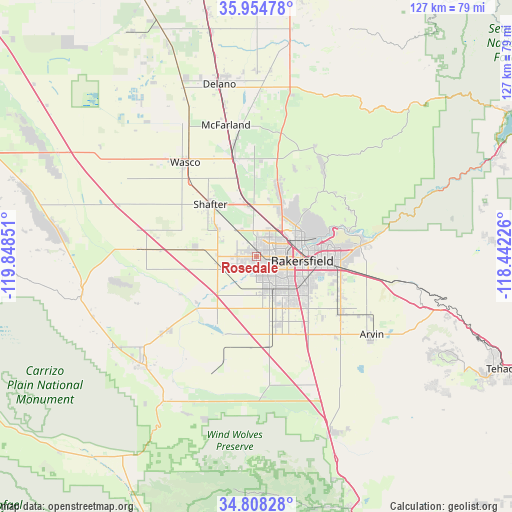
Rosedale GPS coordinates[2]
35° 23' 0.852" North, 119° 8' 43.368" West
| Map corner | latitude | longitude |
|---|---|---|
| Upper-left | 35.95478°, | -119.84851° |
| Center: | 35.38357°, | -119.14538° |
| Lower-right: | 34.80828°, | -118.44226° |
| Map W x H: | 127.5×127.5 km | = 79.2×79.2mi |
| max Lat: | 71.29058° ⇑73.3% North |
| Rosedale: | 35.38357° |
| min Lat: | ⇓26.7% South 19.06759° |
| min Long | Rosedale | max Long |
| -171.73463° | -119.14538° | -66.98998° |
| W 8%⇐ | ⇒92% E |
Elevation
Elevation of Rosedale is 116 m = 381 ft, and this is 178.8 m = 587 ft below average elevation for this country.
| Max E: |
3189 m = 10463 ft | 67.3% |
| Avg. | 294.8 m = 967 ft | |
| Rosedale | 116 m = 381 ft | |
Min E: |
-60 m = -197 ft | 32.7% |
See also: United States elevation on elevation.city.
Geographical zone
Rosedale is located in North temperate zone (between Tropic of Cancer and the Arctic Circle). Distance of this Northern Tropic circle is 1328.4 km =825.4 mi to South.| Distance of | km | miles | from Rosedale |
|---|---|---|---|
| North Pole | 6072.8 | 3773.5 | to North |
| Arctic Circle | 3466.9 | 2154.2 | to North |
| Tropic Cancer | 1328.4 | 825.4 | to South |
| Equator | 3934.3 | 2444.7 | to South |


Nearby cities:
15 places around Rosedale: (largest is in red/bold)
• Arvin
34.7 km =21.6 mi,  123°
123°
• Bakersfield
11.5 km =7.1 mi,  95°
95°
• Buttonwillow
29.4 km =18.3 mi,  273°
273°
• Dustin Acres
28.8 km =17.9 mi,  230°
230°
• Fuller Acres
23.1 km =14.4 mi,  113°
113°
• Greenacres
3.2 km =2 mi,  90°
90°
• Greenfield
18.2 km =11.3 mi,  134°
134°
• Lamont
25.1 km =15.6 mi, 123°
• McFarland
33.6 km =20.9 mi,  346°
346°
• Oildale
12.1 km =7.5 mi,  70°
70°
• Shafter
17.3 km =10.7 mi,  318°
318°
• Smith Corner
16 km =9.9 mi,  311°
311°
• Valley Acres
30.9 km =19.2 mi, 230°
• Wasco
29.4 km =18.3 mi, 322°
• Weedpatch
26.4 km =16.4 mi, 127°
Sources, notices
• [Note1] Compared only with cities in United States existing in our database
• [Src1] Map data: © OpenStreetMap contributors (CC-BY-SA)
• [Src2] Other city data from geonames.org with taken over terms of usage.
• [Src3] Geographical zone / Annual Mean Temperature by Robert A. Rohde @ Wikipedia
