Greenacres geodata
Greenacres (California) is a populated place; located in United States in America/Los_Angeles (GMT-7) time zone. With population of 5,566 people, there are 6708 cities with bigger population in this country. Compared to other cities in United States, 73.3% of cities are located further ↑North; 92% of cities are located further →East and 66.6% of cities have higher elevation than Greenacres. Note1


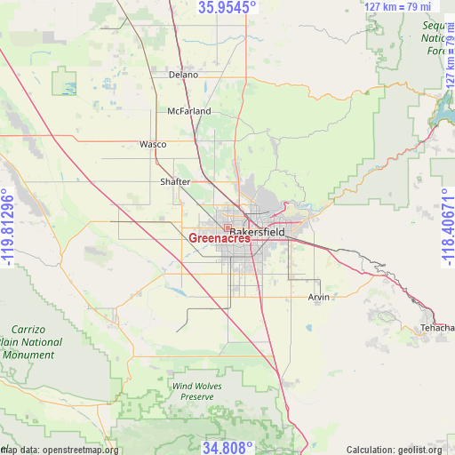
Greenacres GPS coordinates[2]
35° 22' 59.844" North, 119° 6' 35.388" West
| Map corner | latitude | longitude |
|---|---|---|
| Upper-left | 35.9545°, | -119.81296° |
| Center: | 35.38329°, | -119.10983° |
| Lower-right: | 34.808°, | -118.40671° |
| Map W x H: | 127.5×127.5 km | = 79.2×79.2mi |
| max Lat: | 71.29058° ⇑73.3% North |
| Greenacres: | 35.38329° |
| min Lat: | ⇓26.7% South 19.06759° |
| min Long | Greenacres | max Long |
| -171.73463° | -119.10983° | -66.98998° |
| W 8%⇐ | ⇒92% E |
Elevation
Elevation of Greenacres is 120 m = 394 ft, and this is 174.8 m = 573 ft below average elevation for this country.
| Max E: |
3189 m = 10463 ft | 66.6% |
| Avg. | 294.8 m = 967 ft | |
| Greenacres | 120 m = 394 ft | |
Min E: |
-60 m = -197 ft | 33.4% |
See also: United States elevation on elevation.city.
Geographical zone
Greenacres is located in North temperate zone (between Tropic of Cancer and the Arctic Circle). Distance of this Northern Tropic circle is 1328.3 km =825.4 mi to South.| Distance of | km | miles | from Greenacres |
|---|---|---|---|
| North Pole | 6072.8 | 3773.5 | to North |
| Arctic Circle | 3466.9 | 2154.2 | to North |
| Tropic Cancer | 1328.3 | 825.4 | to South |
| Equator | 3934.3 | 2444.7 | to South |


Nearby cities:
15 places around Greenacres: (largest is in red/bold)
• Arvin
32 km =19.9 mi,  127°
127°
• Bakersfield
8.3 km =5.2 mi,  97°
97°
• Buttonwillow
32.7 km =20.3 mi,  273°
273°
• Dustin Acres
31.3 km =19.4 mi,  234°
234°
• Fuller Acres
20.2 km =12.6 mi,  117°
117°
• Greenfield
16 km =9.9 mi,  142°
142°
• Lamont
22.4 km =13.9 mi, 127°
• McFarland
34.5 km =21.4 mi,  341°
341°
• Oildale
9.1 km =5.7 mi,  63°
63°
• Rosedale
3.2 km =2 mi, 270°
• Shafter
19.6 km =12.2 mi,  311°
311°
• Smith Corner
18.6 km =11.6 mi,  304°
304°
• Valley Acres
33.4 km =20.8 mi, 233°
• Wasco
31.4 km =19.5 mi,  318°
318°
• Weedpatch
23.9 km =14.9 mi, 132°
Sources, notices
• [Note1] Compared only with cities in United States existing in our database
• [Src1] Map data: © OpenStreetMap contributors (CC-BY-SA)
• [Src2] Other city data from geonames.org with taken over terms of usage.
• [Src3] Geographical zone / Annual Mean Temperature by Robert A. Rohde @ Wikipedia
