Tulare geodata
Tulare (California) is a populated place; located in United States in America/Los_Angeles (GMT-7) time zone. With population of 62,315 people, there are 704 cities with bigger population in this country. Compared to other cities in United States, 69.4% of cities are located further ↑North; 92.3% of cities are located further →East and 71.7% of cities have higher elevation than Tulare. Note1


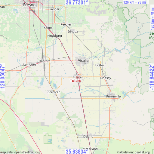
Tulare GPS coordinates[2]
36° 12' 27.828" North, 119° 20' 50.424" West
| Map corner | latitude | longitude |
|---|---|---|
| Upper-left | 36.77301°, | -120.05047° |
| Center: | 36.20773°, | -119.34734° |
| Lower-right: | 35.63834°, | -118.64422° |
| Map W x H: | 126.2×126.2 km | = 78.4×78.4mi |
| max Lat: | 71.29058° ⇑69.4% North |
| Tulare: | 36.20773° |
| min Lat: | ⇓30.6% South 19.06759° |
| min Long | Tulare | max Long |
| -171.73463° | -119.34734° | -66.98998° |
| W 7.7%⇐ | ⇒92.3% E |
Elevation
Elevation of Tulare is 91 m = 299 ft, and this is 203.8 m = 669 ft below average elevation for this country.
| Max E: |
3189 m = 10463 ft | 71.7% |
| Avg. | 294.8 m = 967 ft | |
| Tulare | 91 m = 299 ft | |
Min E: |
-60 m = -197 ft | 28.3% |
See also: Tulare elevation on elevation.city.
Geographical zone
Tulare is located in North temperate zone (between Tropic of Cancer and the Arctic Circle). Distance of this Northern Tropic circle is 1420 km =882.3 mi to South.| Distance of | km | miles | from Tulare |
|---|---|---|---|
| North Pole | 5981.1 | 3716.5 | to North |
| Arctic Circle | 3375.3 | 2097.3 | to North |
| Tropic Cancer | 1420 | 882.3 | to South |
| Equator | 4025.9 | 2501.6 | to South |


Nearby cities:
15 places around Tulare: (largest is in red/bold)
• Corcoran
22.7 km =14.1 mi,  237°
237°
• East Tulare Villa
5.9 km =3.7 mi,  94°
94°
• Exeter
20.9 km =13 mi,  61°
61°
• Farmersville
16.1 km =10 mi,  51°
51°
• Goshen
17.2 km =10.7 mi,  337°
337°
• Ivanhoe
23.1 km =14.4 mi,  30°
30°
• Lindsay
23.3 km =14.5 mi, 91°
• Linnell Camp
15.9 km =9.9 mi,  44°
44°
• Matheny
4.1 km =2.5 mi,  185°
185°
• Patterson Tract
19.7 km =12.2 mi,  13°
13°
• Plainview
20.4 km =12.7 mi,  110°
110°
• Poplar-Cotton Center
24.5 km =15.2 mi,  133°
133°
• Tipton
16.8 km =10.4 mi,  169°
169°
• Visalia
14.5 km =9 mi,  19°
19°
• Woodville
18.4 km =11.4 mi, 133°
Sources, notices
• [Note1] Compared only with cities in United States existing in our database
• [Src1] Map data: © OpenStreetMap contributors (CC-BY-SA)
• [Src2] Other city data from geonames.org with taken over terms of usage.
• [Src3] Geographical zone / Annual Mean Temperature by Robert A. Rohde @ Wikipedia
