Blende geodata
Blende (Colorado) is a populated place; located in United States in America/Denver (GMT-6) time zone. With population of 878 people, there are 17129 cities with bigger population in this country. Compared to other cities in United States, 60.3% of cities are located further ↑North; 82.8% of cities are located further →East and 96.3% of cities have lower elevation than Blende. Note1


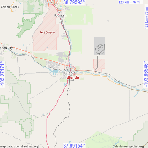
Blende GPS coordinates[2]
38° 14' 45.024" North, 104° 34' 6.888" West
| Map corner | latitude | longitude |
|---|---|---|
| Upper-left | 38.79595°, | -105.27171° |
| Center: | 38.24584°, | -104.56858° |
| Lower-right: | 37.69154°, | -103.86546° |
| Map W x H: | 122.8×122.8 km | = 76.3×76.3mi |
| max Lat: | 71.29058° ⇑60.3% North |
| Blende: | 38.24584° |
| min Lat: | ⇓39.7% South 19.06759° |
| min Long | Blende | max Long |
| -171.73463° | -104.56858° | -66.98998° |
| W 17.2%⇐ | ⇒82.8% E |
Elevation
Elevation of Blende is 1447 m = 4747 ft, and this is 1152.2 m = 3780 ft above average elevation for this country.
| Max E: |
3189 m = 10463 ft | 3.7% |
| Blende | 1447 m 4747 ft | |
| Avg. | 294.8 m = 967 ft | |
Min E: |
-60 m = -197 ft | 96.3% |
See also: United States elevation on elevation.city.
Geographical zone
Blende is located in North temperate zone (between Tropic of Cancer and the Arctic Circle). Distance of this Northern Tropic circle is 1646.6 km =1023.1 mi to South.| Distance of | km | miles | from Blende |
|---|---|---|---|
| North Pole | 5754.5 | 3575.7 | to North |
| Arctic Circle | 3148.6 | 1956.4 | to North |
| Tropic Cancer | 1646.6 | 1023.1 | to South |
| Equator | 4252.5 | 2642.4 | to South |


Nearby cities:
15 places around Blende: (largest is in red/bold)
• Avondale
19 km =11.8 mi,  92°
92°
• Beulah Valley
39.8 km =24.7 mi,  240°
240°
• Colorado City
40.8 km =25.4 mi,  214°
214°
• Florence
50.6 km =31.4 mi,  288°
288°
• Fort Carson
57.9 km =36 mi,  340°
340°
• Fountain
49.9 km =31 mi,  346°
346°
• Fowler
49.4 km =30.7 mi,  105°
105°
• Lincoln Park
60.4 km =37.5 mi, 289°
• Penrose
44.3 km =27.5 mi,  296°
296°
• Pueblo
3.7 km =2.3 mi, 285°
• Pueblo West
17.8 km =11.1 mi,  310°
310°
• Salt Creek
1.8 km =1.1 mi, 242°
• Security-Widefield
57.2 km =35.5 mi, 347°
• Stratmoor
61.5 km =38.2 mi, 342°
• Williamsburg
53.1 km =33 mi, 286°
Sources, notices
• [Note1] Compared only with cities in United States existing in our database
• [Src1] Map data: © OpenStreetMap contributors (CC-BY-SA)
• [Src2] Other city data from geonames.org with taken over terms of usage.
• [Src3] Geographical zone / Annual Mean Temperature by Robert A. Rohde @ Wikipedia
