Fowler geodata
Fowler (Colorado) is a populated place; located in United States in America/Denver (GMT-6) time zone. With population of 1,148 people, there are 15391 cities with bigger population in this country. Compared to other cities in United States, 61% of cities are located further ↑North; 82.7% of cities are located further →East and 95.4% of cities have lower elevation than Fowler. Note1


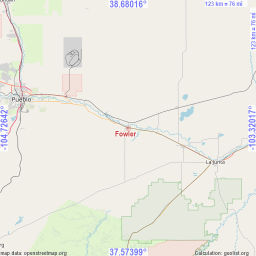
Fowler GPS coordinates[2]
38° 7' 45.012" North, 104° 1' 23.844" West
| Map corner | latitude | longitude |
|---|---|---|
| Upper-left | 38.68016°, | -104.72642° |
| Center: | 38.12917°, | -104.02329° |
| Lower-right: | 37.57399°, | -103.32017° |
| Map W x H: | 123×123 km | = 76.4×76.4mi |
| max Lat: | 71.29058° ⇑61% North |
| Fowler: | 38.12917° |
| min Lat: | ⇓39% South 19.06759° |
| min Long | Fowler | max Long |
| -171.73463° | -104.02329° | -66.98998° |
| W 17.3%⇐ | ⇒82.7% E |
Elevation
Elevation of Fowler is 1328 m = 4357 ft, and this is 1033.2 m = 3390 ft above average elevation for this country.
| Max E: |
3189 m = 10463 ft | 4.6% |
| Fowler | 1328 m 4357 ft | |
| Avg. | 294.8 m = 967 ft | |
Min E: |
-60 m = -197 ft | 95.4% |
See also: United States elevation on elevation.city.
Geographical zone
Fowler is located in North temperate zone (between Tropic of Cancer and the Arctic Circle). Distance of this Northern Tropic circle is 1633.6 km =1015.1 mi to South.| Distance of | km | miles | from Fowler |
|---|---|---|---|
| North Pole | 5767.5 | 3583.8 | to North |
| Arctic Circle | 3161.6 | 1964.5 | to North |
| Tropic Cancer | 1633.6 | 1015.1 | to South |
| Equator | 4239.6 | 2634.4 | to South |


Nearby cities:
15 places around Fowler: (largest is in red/bold)
• Avondale
31.1 km =19.3 mi,  292°
292°
• Beulah Valley
82.8 km =51.4 mi,  265°
265°
• Blende
49.4 km =30.7 mi, 285°
• Colorado City
74 km =46 mi,  253°
253°
• Ellicott
85 km =52.8 mi,  338°
338°
• Fountain
85.2 km =52.9 mi,  316°
316°
• La Junta
44.9 km =27.9 mi,  110°
110°
• Las Animas
70.4 km =43.7 mi,  95°
95°
• North La Junta
45.5 km =28.3 mi, 108°
• Ordway
25.4 km =15.8 mi,  67°
67°
• Pueblo
53.1 km =33 mi, 285°
• Pueblo West
65.8 km =40.9 mi, 291°
• Rocky Ford
27.9 km =17.3 mi, 107°
• Salt Creek
50.8 km =31.6 mi,  283°
283°
• Swink
36.9 km =22.9 mi, 110°
Sources, notices
• [Note1] Compared only with cities in United States existing in our database
• [Src1] Map data: © OpenStreetMap contributors (CC-BY-SA)
• [Src2] Other city data from geonames.org with taken over terms of usage.
• [Src3] Geographical zone / Annual Mean Temperature by Robert A. Rohde @ Wikipedia
