Arvada geodata
Arvada (Colorado) is a populated place; located in United States in America/Denver (GMT-6) time zone. With population of 115,368 people, there are 276 cities with bigger population in this country. Compared to other cities in United States, 51.5% of cities are located further ↓South; 83.4% of cities are located further →East and 97.6% of cities have lower elevation than Arvada. Note1


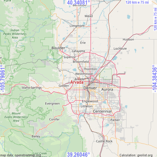
Arvada GPS coordinates[2]
39° 48' 9.936" North, 105° 5' 14.928" West
| Map corner | latitude | longitude |
|---|---|---|
| Upper-left | 40.34081°, | -105.79061° |
| Center: | 39.80276°, | -105.08748° |
| Lower-right: | 39.26046°, | -104.38436° |
| Map W x H: | 120.1×120.1 km | = 74.6×74.6mi |
| max Lat: | 71.29058° ⇑48.5% North |
| Arvada: | 39.80276° |
| min Lat: | ⇓51.5% South 19.06759° |
| min Long | Arvada | max Long |
| -171.73463° | -105.08748° | -66.98998° |
| W 16.6%⇐ | ⇒83.4% E |
Elevation
Elevation of Arvada is 1637 m = 5371 ft, and this is 1342.2 m = 4404 ft above average elevation for this country.
| Max E: |
3189 m = 10463 ft | 2.4% |
| Arvada | 1637 m 5371 ft | |
| Avg. | 294.8 m = 967 ft | |
Min E: |
-60 m = -197 ft | 97.6% |
See also: Arvada elevation on elevation.city.
Geographical zone
Arvada is located in North temperate zone (between Tropic of Cancer and the Arctic Circle). Distance of this Northern Tropic circle is 1819.7 km =1130.7 mi to South.| Distance of | km | miles | from Arvada |
|---|---|---|---|
| North Pole | 5581.4 | 3468.1 | to North |
| Arctic Circle | 2975.5 | 1848.9 | to North |
| Tropic Cancer | 1819.7 | 1130.7 | to South |
| Equator | 4425.7 | 2750 | to South |


Nearby cities:
15 places around Arvada: (largest is in red/bold)
• Applewood
8.1 km =5 mi,  232°
232°
• Berkley
5.2 km =3.2 mi,  87°
87°
• Denver
11.3 km =7 mi,  128°
128°
• Edgewater
5.9 km =3.7 mi,  160°
160°
• Federal Heights
9.3 km =5.8 mi,  54°
54°
• Lakewood
10.9 km =6.8 mi,  177°
177°
• Mountain View
4.2 km =2.6 mi,  139°
139°
• Shaw Heights
6.7 km =4.2 mi,  34°
34°
• Sherrelwood
8.3 km =5.2 mi,  62°
62°
• Thornton
12.2 km =7.6 mi, 53°
• Twin Lakes
7.5 km =4.7 mi,  70°
70°
• Welby
11.6 km =7.2 mi, 71°
• West Pleasant View
11 km =6.8 mi,  224°
224°
• Westminster
5.7 km =3.5 mi, 48°
• Wheat Ridge
4.2 km =2.6 mi,  167°
167°
Sources, notices
• [Note1] Compared only with cities in United States existing in our database
• [Src1] Map data: © OpenStreetMap contributors (CC-BY-SA)
• [Src2] Other city data from geonames.org with taken over terms of usage.
• [Src3] Geographical zone / Annual Mean Temperature by Robert A. Rohde @ Wikipedia
