Westminster geodata
Westminster (Colorado) is a populated place; located in United States in America/Denver (GMT-6) time zone. With population of 113,130 people, there are 285 cities with bigger population in this country. Compared to other cities in United States, 51.8% of cities are located further ↓South; 83.3% of cities are located further →East and 97.6% of cities have lower elevation than Westminster. Note1


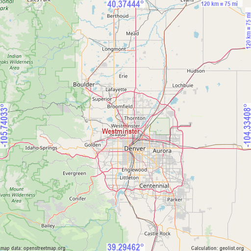
Westminster GPS coordinates[2]
39° 50' 11.94" North, 105° 2' 13.92" West
| Map corner | latitude | longitude |
|---|---|---|
| Upper-left | 40.37444°, | -105.74033° |
| Center: | 39.83665°, | -105.0372° |
| Lower-right: | 39.29462°, | -104.33408° |
| Map W x H: | 120.1×120.1 km | = 74.6×74.6mi |
| max Lat: | 71.29058° ⇑48.2% North |
| Westminster: | 39.83665° |
| min Lat: | ⇓51.8% South 19.06759° |
| min Long | Westminster | max Long |
| -171.73463° | -105.0372° | -66.98998° |
| W 16.7%⇐ | ⇒83.3% E |
Elevation
Elevation of Westminster is 1644 m = 5394 ft, and this is 1349.2 m = 4427 ft above average elevation for this country.
| Max E: |
3189 m = 10463 ft | 2.4% |
| Westminster | 1644 m 5394 ft | |
| Avg. | 294.8 m = 967 ft | |
Min E: |
-60 m = -197 ft | 97.6% |
See also: Westminster elevation on elevation.city.
Geographical zone
Westminster is located in North temperate zone (between Tropic of Cancer and the Arctic Circle). Distance of this Northern Tropic circle is 1823.5 km =1133.1 mi to South.| Distance of | km | miles | from Westminster |
|---|---|---|---|
| North Pole | 5577.6 | 3465.8 | to North |
| Arctic Circle | 2971.8 | 1846.6 | to North |
| Tropic Cancer | 1823.5 | 1133.1 | to South |
| Equator | 4429.4 | 2752.3 | to South |


Nearby cities:
15 places around Westminster: (largest is in red/bold)
• Arvada
5.7 km =3.5 mi,  228°
228°
• Berkley
3.7 km =2.3 mi,  165°
165°
• Broomfield
10.2 km =6.3 mi,  335°
335°
• Commerce City
9.4 km =5.8 mi,  109°
109°
• Derby
10.1 km =6.3 mi,  88°
88°
• Edgewater
9.6 km =6 mi,  193°
193°
• Federal Heights
3.7 km =2.3 mi,  63°
63°
• Mountain View
7.1 km =4.4 mi, 192°
• Northglenn
6.9 km =4.3 mi,  38°
38°
• Shaw Heights
1.8 km =1.1 mi, 344°
• Sherrelwood
3.1 km =1.9 mi, 87°
• Thornton
6.6 km =4.1 mi, 57°
• Twin Lakes
3.1 km =1.9 mi,  115°
115°
• Welby
6.7 km =4.2 mi, 90°
• Wheat Ridge
8.6 km =5.3 mi,  203°
203°
Sources, notices
• [Note1] Compared only with cities in United States existing in our database
• [Src1] Map data: © OpenStreetMap contributors (CC-BY-SA)
• [Src2] Other city data from geonames.org with taken over terms of usage.
• [Src3] Geographical zone / Annual Mean Temperature by Robert A. Rohde @ Wikipedia
