Paonia geodata
Paonia (Colorado) is a populated place; located in United States in America/Denver (GMT-6) time zone. With population of 1,405 people, there are 14089 cities with bigger population in this country. Compared to other cities in United States, 56.1% of cities are located further ↑North; 84.8% of cities are located further →East and 98.1% of cities have lower elevation than Paonia. Note1


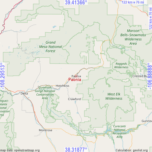
Paonia GPS coordinates[2]
38° 52' 5.952" North, 107° 35' 31.2" West
| Map corner | latitude | longitude |
|---|---|---|
| Upper-left | 39.41366°, | -108.29513° |
| Center: | 38.86832°, | -107.592° |
| Lower-right: | 38.31877°, | -106.88888° |
| Map W x H: | 121.7×121.7 km | = 75.6×75.6mi |
| max Lat: | 71.29058° ⇑56.1% North |
| Paonia: | 38.86832° |
| min Lat: | ⇓43.9% South 19.06759° |
| min Long | Paonia | max Long |
| -171.73463° | -107.592° | -66.98998° |
| W 15.2%⇐ | ⇒84.8% E |
Elevation
Elevation of Paonia is 1739 m = 5705 ft, and this is 1444.2 m = 4738 ft above average elevation for this country.
| Max E: |
3189 m = 10463 ft | 1.9% |
| Paonia | 1739 m 5705 ft | |
| Avg. | 294.8 m = 967 ft | |
Min E: |
-60 m = -197 ft | 98.1% |
See also: United States elevation on elevation.city.
Geographical zone
Paonia is located in North temperate zone (between Tropic of Cancer and the Arctic Circle). Distance of this Northern Tropic circle is 1715.8 km =1066.1 mi to South.| Distance of | km | miles | from Paonia |
|---|---|---|---|
| North Pole | 5685.3 | 3532.7 | to North |
| Arctic Circle | 3079.4 | 1913.4 | to North |
| Tropic Cancer | 1715.8 | 1066.1 | to South |
| Equator | 4321.8 | 2685.4 | to South |


Nearby cities:
15 places around Paonia: (largest is in red/bold)
• Carbondale
67.8 km =42.1 mi,  28°
28°
• Cattle Creek
71.5 km =44.4 mi,  23°
23°
• Cedaredge
29.2 km =18.1 mi,  277°
277°
• Collbran
52.2 km =32.4 mi,  322°
322°
• Crested Butte
52.3 km =32.5 mi,  89°
89°
• Delta
43.6 km =27.1 mi,  251°
251°
• El Jebel
72.8 km =45.2 mi,  36°
36°
• Gunnison
68.1 km =42.3 mi,  121°
121°
• Hotchkiss
13.4 km =8.3 mi,  235°
235°
• Montrose
49.9 km =31 mi,  209°
209°
• Mount Crested Butte
54.8 km =34.1 mi, 85°
• Olathe
44.8 km =27.8 mi,  229°
229°
• Orchard City
33.1 km =20.6 mi,  262°
262°
• Palisade
70.9 km =44.1 mi,  292°
292°
• Snowmass Village
68.3 km =42.4 mi,  55°
55°
Sources, notices
• [Note1] Compared only with cities in United States existing in our database
• [Src1] Map data: © OpenStreetMap contributors (CC-BY-SA)
• [Src2] Other city data from geonames.org with taken over terms of usage.
• [Src3] Geographical zone / Annual Mean Temperature by Robert A. Rohde @ Wikipedia
