Edgewater geodata
Edgewater (Colorado) is a populated place; located in United States in America/Denver (GMT-6) time zone. With population of 5,302 people, there are 6905 cities with bigger population in this country. Compared to other cities in United States, 51.1% of cities are located further ↓South; 83.4% of cities are located further →East and 97.7% of cities have lower elevation than Edgewater. Note1


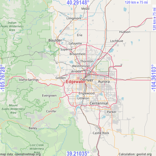
Edgewater GPS coordinates[2]
39° 45' 10.944" North, 105° 3' 50.94" West
| Map corner | latitude | longitude |
|---|---|---|
| Upper-left | 40.29148°, | -105.76728° |
| Center: | 39.75304°, | -105.06415° |
| Lower-right: | 39.21035°, | -104.36103° |
| Map W x H: | 120.2×120.2 km | = 74.7×74.7mi |
| max Lat: | 71.29058° ⇑48.9% North |
| Edgewater: | 39.75304° |
| min Lat: | ⇓51.1% South 19.06759° |
| min Long | Edgewater | max Long |
| -171.73463° | -105.06415° | -66.98998° |
| W 16.6%⇐ | ⇒83.4% E |
Elevation
Elevation of Edgewater is 1645 m = 5397 ft, and this is 1350.2 m = 4430 ft above average elevation for this country.
| Max E: |
3189 m = 10463 ft | 2.3% |
| Edgewater | 1645 m 5397 ft | |
| Avg. | 294.8 m = 967 ft | |
Min E: |
-60 m = -197 ft | 97.7% |
See also: United States elevation on elevation.city.
Geographical zone
Edgewater is located in North temperate zone (between Tropic of Cancer and the Arctic Circle). Distance of this Northern Tropic circle is 1814.2 km =1127.3 mi to South.| Distance of | km | miles | from Edgewater |
|---|---|---|---|
| North Pole | 5586.9 | 3471.5 | to North |
| Arctic Circle | 2981.1 | 1852.4 | to North |
| Tropic Cancer | 1814.2 | 1127.3 | to South |
| Equator | 4420.1 | 2746.5 | to South |


Nearby cities:
15 places around Edgewater: (largest is in red/bold)
• Applewood
8.4 km =5.2 mi,  273°
273°
• Arvada
5.9 km =3.7 mi,  340°
340°
• Berkley
6.6 km =4.1 mi,  29°
29°
• Denver
7 km =4.3 mi,  102°
102°
• Federal Heights
12.3 km =7.6 mi, 27°
• Glendale
12.4 km =7.7 mi,  115°
115°
• Lakewood
5.6 km =3.5 mi,  195°
195°
• Mountain View
2.5 km =1.6 mi,  17°
17°
• Shaw Heights
11.2 km =7 mi,  9°
9°
• Sheridan
12.3 km =7.6 mi,  164°
164°
• Sherrelwood
10.8 km =6.7 mi, 29°
• Twin Lakes
9.5 km =5.9 mi, 32°
• West Pleasant View
10 km =6.2 mi,  256°
256°
• Westminster
9.6 km =6 mi, 13°
• Wheat Ridge
1.8 km =1.1 mi,  322°
322°
Sources, notices
• [Note1] Compared only with cities in United States existing in our database
• [Src1] Map data: © OpenStreetMap contributors (CC-BY-SA)
• [Src2] Other city data from geonames.org with taken over terms of usage.
• [Src3] Geographical zone / Annual Mean Temperature by Robert A. Rohde @ Wikipedia
