Bayfield geodata
Bayfield (Colorado) is a populated place; located in United States in America/Denver (GMT-6) time zone. With population of 2,567 people, there are 10463 cities with bigger population in this country. Compared to other cities in United States, 65.2% of cities are located further ↑North; 84.9% of cities are located further →East and 99.4% of cities have lower elevation than Bayfield. Note1


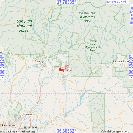
Bayfield GPS coordinates[2]
37° 13' 32.016" North, 107° 35' 53.196" West
| Map corner | latitude | longitude |
|---|---|---|
| Upper-left | 37.78335°, | -108.30124° |
| Center: | 37.22556°, | -107.59811° |
| Lower-right: | 36.66362°, | -106.89499° |
| Map W x H: | 124.5×124.5 km | = 77.4×77.4mi |
| max Lat: | 71.29058° ⇑65.2% North |
| Bayfield: | 37.22556° |
| min Lat: | ⇓34.8% South 19.06759° |
| min Long | Bayfield | max Long |
| -171.73463° | -107.59811° | -66.98998° |
| W 15.1%⇐ | ⇒84.9% E |
Elevation
Elevation of Bayfield is 2108 m = 6916 ft, and this is 1813.2 m = 5949 ft above average elevation for this country.
| Max E: |
3189 m = 10463 ft | 0.59999999999999% |
| Bayfield | 2108 m 6916 ft | |
| Avg. | 294.8 m = 967 ft | |
Min E: |
-60 m = -197 ft | 99.4% |
See also: United States elevation on elevation.city.
Geographical zone
Bayfield is located in North temperate zone (between Tropic of Cancer and the Arctic Circle). Distance of this Northern Tropic circle is 1533.2 km =952.7 mi to South.| Distance of | km | miles | from Bayfield |
|---|---|---|---|
| North Pole | 5868 | 3646.2 | to North |
| Arctic Circle | 3262.1 | 2027 | to North |
| Tropic Cancer | 1533.2 | 952.7 | to South |
| Equator | 4139.1 | 2571.9 | to South |


Nearby cities:
15 places around Bayfield: (largest is in red/bold)
• Aztec
56.9 km =35.4 mi,  218°
218°
• Bloomfield
66.7 km =41.4 mi,  210°
210°
• Cedar Hill
41.3 km =25.7 mi, 218°
• Dulce
62.3 km =38.7 mi,  121°
121°
• Durango
25.6 km =15.9 mi,  282°
282°
• Flora Vista
64.3 km =40 mi, 221°
• Ignacio
12.7 km =7.9 mi,  194°
194°
• La Plata
62.1 km =38.6 mi,  237°
237°
• Lee Acres
70.3 km =43.7 mi, 213°
• Mancos
62.6 km =38.9 mi, 282°
• Navajo
56.7 km =35.2 mi, 123°
• Pagosa Springs
52.3 km =32.5 mi,  84°
84°
• Silverton
65.5 km =40.7 mi,  354°
354°
• Spencerville
60.8 km =37.8 mi, 222°
• West Hammond
72.6 km =45.1 mi, 213°
Sources, notices
• [Note1] Compared only with cities in United States existing in our database
• [Src1] Map data: © OpenStreetMap contributors (CC-BY-SA)
• [Src2] Other city data from geonames.org with taken over terms of usage.
• [Src3] Geographical zone / Annual Mean Temperature by Robert A. Rohde @ Wikipedia
