Loyalton geodata
Loyalton (California) is a populated place; located in United States in America/Los_Angeles (GMT-7) time zone. With population of 702 people, there are 18655 cities with bigger population in this country. Compared to other cities in United States, 50.5% of cities are located further ↓South; 93% of cities are located further →East and 96.7% of cities have lower elevation than Loyalton. Note1


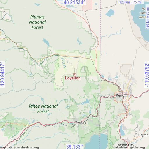
Loyalton GPS coordinates[2]
39° 40' 34.644" North, 120° 14' 27.744" West
| Map corner | latitude | longitude |
|---|---|---|
| Upper-left | 40.21534°, | -120.94417° |
| Center: | 39.67629°, | -120.24104° |
| Lower-right: | 39.133°, | -119.53792° |
| Map W x H: | 120.3×120.3 km | = 74.8×74.8mi |
| max Lat: | 71.29058° ⇑49.5% North |
| Loyalton: | 39.67629° |
| min Lat: | ⇓50.5% South 19.06759° |
| min Long | Loyalton | max Long |
| -171.73463° | -120.24104° | -66.98998° |
| W 7%⇐ | ⇒93% E |
Elevation
Elevation of Loyalton is 1510 m = 4954 ft, and this is 1215.2 m = 3987 ft above average elevation for this country.
| Max E: |
3189 m = 10463 ft | 3.3% |
| Loyalton | 1510 m 4954 ft | |
| Avg. | 294.8 m = 967 ft | |
Min E: |
-60 m = -197 ft | 96.7% |
See also: United States elevation on elevation.city.
Geographical zone
Loyalton is located in North temperate zone (between Tropic of Cancer and the Arctic Circle). Distance of this Northern Tropic circle is 1805.7 km =1122 mi to South.| Distance of | km | miles | from Loyalton |
|---|---|---|---|
| North Pole | 5595.5 | 3476.9 | to North |
| Arctic Circle | 2989.6 | 1857.7 | to North |
| Tropic Cancer | 1805.7 | 1122 | to South |
| Equator | 4411.6 | 2741.2 | to South |


Nearby cities:
15 places around Loyalton: (largest is in red/bold)
• Cold Springs
22.6 km =14 mi,  88°
88°
• Delleker
26.5 km =16.5 mi,  303°
303°
• Doyle
40.8 km =25.4 mi,  16°
16°
• Golden Valley
36.1 km =22.4 mi,  100°
100°
• Graeagle
33.8 km =21 mi,  287°
287°
• Lemmon Valley
34.3 km =21.3 mi, 97°
• Mogul
32.5 km =20.2 mi,  123°
123°
• Portola
24.6 km =15.3 mi,  307°
307°
• Reno
40.1 km =24.9 mi,  114°
114°
• Spanish Springs
45.8 km =28.5 mi, 93°
• Sparks
44.7 km =27.8 mi, 110°
• Sun Valley
40.8 km =25.4 mi, 102°
• Tahoe Vista
51.2 km =31.8 mi,  161°
161°
• Truckee
39 km =24.2 mi,  172°
172°
• Verdi
27.9 km =17.3 mi,  129°
129°
Sources, notices
• [Note1] Compared only with cities in United States existing in our database
• [Src1] Map data: © OpenStreetMap contributors (CC-BY-SA)
• [Src2] Other city data from geonames.org with taken over terms of usage.
• [Src3] Geographical zone / Annual Mean Temperature by Robert A. Rohde @ Wikipedia
