Loraine geodata
Loraine (Texas) is a populated place; located in United States in America/Chicago (GMT-5) time zone. With population of 603 people, there are 19664 cities with bigger population in this country. Compared to other cities in United States, 87.5% of cities are located further ↑North; 81.2% of cities are located further →East and 90.9% of cities have lower elevation than Loraine. Note1


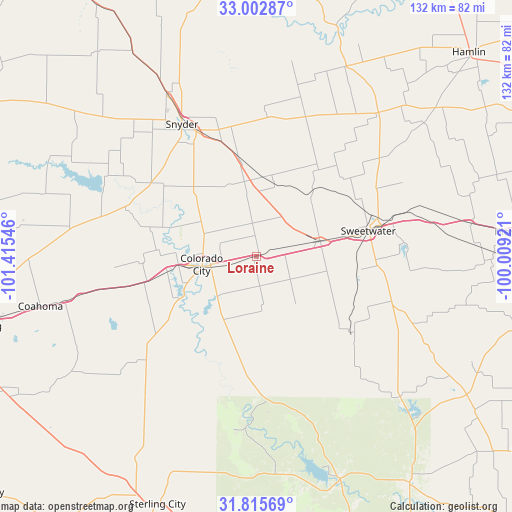
Loraine GPS coordinates[2]
32° 24' 40.428" North, 100° 42' 44.388" West
| Map corner | latitude | longitude |
|---|---|---|
| Upper-left | 33.00287°, | -101.41546° |
| Center: | 32.41123°, | -100.71233° |
| Lower-right: | 31.81569°, | -100.00921° |
| Map W x H: | 132×132 km | = 82×82mi |
| max Lat: | 71.29058° ⇑87.5% North |
| Loraine: | 32.41123° |
| min Lat: | ⇓12.5% South 19.06759° |
| min Long | Loraine | max Long |
| -171.73463° | -100.71233° | -66.98998° |
| W 18.8%⇐ | ⇒81.2% E |
Elevation
Elevation of Loraine is 694 m = 2277 ft, and this is 399.2 m = 1310 ft above average elevation for this country.
| Max E: |
3189 m = 10463 ft | 9.1% |
| Loraine | 694 m 2277 ft | |
| Avg. | 294.8 m = 967 ft | |
Min E: |
-60 m = -197 ft | 90.9% |
See also: United States elevation on elevation.city.
Geographical zone
Loraine is located in North temperate zone (between Tropic of Cancer and the Arctic Circle). Distance of this Northern Tropic circle is 997.9 km =620.1 mi to South.| Distance of | km | miles | from Loraine |
|---|---|---|---|
| North Pole | 6403.3 | 3978.8 | to North |
| Arctic Circle | 3797.4 | 2359.6 | to North |
| Tropic Cancer | 997.9 | 620.1 | to South |
| Equator | 3603.8 | 2239.3 | to South |


Nearby cities:
15 places around Loraine: (largest is in red/bold)
• Big Spring
74.2 km =46.1 mi,  256°
256°
• Bronte
70.4 km =43.7 mi,  145°
145°
• Coahoma
57.2 km =35.5 mi, 257°
• Colorado City
14.5 km =9 mi, 259°
• Hamlin
76 km =47.2 mi,  46°
46°
• Merkel
66 km =41 mi,  84°
84°
• Robert Lee
61.5 km =38.2 mi,  159°
159°
• Roby
48.6 km =30.2 mi,  40°
40°
• Roscoe
16.7 km =10.4 mi, 76°
• Rotan
54.2 km =33.7 mi,  25°
25°
• Sand Springs
61.7 km =38.3 mi, 256°
• Snyder
39.1 km =24.3 mi,  330°
330°
• Sterling City
68.9 km =42.8 mi,  201°
201°
• Sweetwater
29.5 km =18.3 mi, 76°
• Tye
79.1 km =49.2 mi,  86°
86°
Sources, notices
• [Note1] Compared only with cities in United States existing in our database
• [Src1] Map data: © OpenStreetMap contributors (CC-BY-SA)
• [Src2] Other city data from geonames.org with taken over terms of usage.
• [Src3] Geographical zone / Annual Mean Temperature by Robert A. Rohde @ Wikipedia
