Merkel geodata
Merkel (Texas) is a populated place; located in United States in America/Chicago (GMT-5) time zone. With population of 2,615 people, there are 10366 cities with bigger population in this country. Compared to other cities in United States, 87.2% of cities are located further ↑North; 80.8% of cities are located further →East and 89.2% of cities have lower elevation than Merkel. Note1


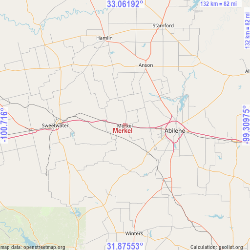
Merkel GPS coordinates[2]
32° 28' 14.448" North, 100° 0' 46.332" West
| Map corner | latitude | longitude |
|---|---|---|
| Upper-left | 33.06192°, | -100.716° |
| Center: | 32.47068°, | -100.01287° |
| Lower-right: | 31.87553°, | -99.30975° |
| Map W x H: | 131.9×131.9 km | = 82×82mi |
| max Lat: | 71.29058° ⇑87.2% North |
| Merkel: | 32.47068° |
| min Lat: | ⇓12.8% South 19.06759° |
| min Long | Merkel | max Long |
| -171.73463° | -100.01287° | -66.98998° |
| W 19.2%⇐ | ⇒80.8% E |
Elevation
Elevation of Merkel is 572 m = 1877 ft, and this is 277.2 m = 909 ft above average elevation for this country.
| Max E: |
3189 m = 10463 ft | 10.8% |
| Merkel | 572 m 1877 ft | |
| Avg. | 294.8 m = 967 ft | |
Min E: |
-60 m = -197 ft | 89.2% |
See also: United States elevation on elevation.city.
Geographical zone
Merkel is located in North temperate zone (between Tropic of Cancer and the Arctic Circle). Distance of this Northern Tropic circle is 1004.5 km =624.2 mi to South.| Distance of | km | miles | from Merkel |
|---|---|---|---|
| North Pole | 6396.7 | 3974.7 | to North |
| Arctic Circle | 3790.8 | 2355.5 | to North |
| Tropic Cancer | 1004.5 | 624.2 | to South |
| Equator | 3610.4 | 2243.4 | to South |


Nearby cities:
15 places around Merkel: (largest is in red/bold)
• Abilene
26.4 km =16.4 mi,  95°
95°
• Anson
33.6 km =20.9 mi,  18°
18°
• Baird
58.7 km =36.5 mi, 98°
• Clyde
49.2 km =30.6 mi, 98°
• Hamlin
47.3 km =29.4 mi,  346°
346°
• Hawley
24.4 km =15.2 mi,  49°
49°
• Potosi
37 km =23 mi,  115°
115°
• Roby
45.8 km =28.5 mi,  311°
311°
• Roscoe
49.4 km =30.7 mi,  266°
266°
• Rotan
60 km =37.3 mi,  315°
315°
• Stamford
56.3 km =35 mi, 20°
• Sweetwater
36.9 km =22.9 mi, 270°
• Tuscola
35.4 km =22 mi,  145°
145°
• Tye
13.3 km =8.3 mi, 96°
• Winters
57.4 km =35.7 mi,  175°
175°
Sources, notices
• [Note1] Compared only with cities in United States existing in our database
• [Src1] Map data: © OpenStreetMap contributors (CC-BY-SA)
• [Src2] Other city data from geonames.org with taken over terms of usage.
• [Src3] Geographical zone / Annual Mean Temperature by Robert A. Rohde @ Wikipedia
