Roby geodata
Roby (Texas) is a seat of a second-order administrative division; located in United States in America/Chicago (GMT-5) time zone. With population of 621 people, there are 19457 cities with bigger population in this country. Compared to other cities in United States, 86.2% of cities are located further ↑North; 80.9% of cities are located further →East and 89.7% of cities have lower elevation than Roby. Note1


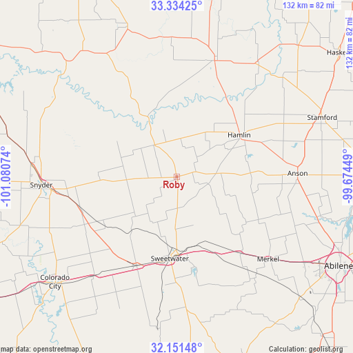
Roby GPS coordinates[2]
32° 44' 41.388" North, 100° 22' 39.396" West
| Map corner | latitude | longitude |
|---|---|---|
| Upper-left | 33.33425°, | -101.08074° |
| Center: | 32.74483°, | -100.37761° |
| Lower-right: | 32.15148°, | -99.67449° |
| Map W x H: | 131.5×131.5 km | = 81.7×81.7mi |
| max Lat: | 71.29058° ⇑86.2% North |
| Roby: | 32.74483° |
| min Lat: | ⇓13.8% South 19.06759° |
| min Long | Roby | max Long |
| -171.73463° | -100.37761° | -66.98998° |
| W 19.1%⇐ | ⇒80.9% E |
Elevation
Elevation of Roby is 600 m = 1969 ft, and this is 305.2 m = 1001 ft above average elevation for this country.
| Max E: |
3189 m = 10463 ft | 10.3% |
| Roby | 600 m 1969 ft | |
| Avg. | 294.8 m = 967 ft | |
Min E: |
-60 m = -197 ft | 89.7% |
See also: United States elevation on elevation.city.
Geographical zone
Roby is located in North temperate zone (between Tropic of Cancer and the Arctic Circle). Distance of this Northern Tropic circle is 1035 km =643.1 mi to South.| Distance of | km | miles | from Roby |
|---|---|---|---|
| North Pole | 6366.2 | 3955.8 | to North |
| Arctic Circle | 3760.3 | 2336.5 | to North |
| Tropic Cancer | 1035 | 643.1 | to South |
| Equator | 3640.9 | 2262.3 | to South |


Nearby cities:
15 places around Roby: (largest is in red/bold)
• Anson
45 km =28 mi,  88°
88°
• Aspermont
45.4 km =28.2 mi,  17°
17°
• Colorado City
60.5 km =37.6 mi,  229°
229°
• Hamlin
28.2 km =17.5 mi,  56°
56°
• Hawley
54.8 km =34.1 mi,  105°
105°
• Jayton
58.9 km =36.6 mi,  341°
341°
• Loraine
48.6 km =30.2 mi,  220°
220°
• Merkel
45.8 km =28.5 mi,  131°
131°
• Roscoe
36.5 km =22.7 mi,  204°
204°
• Rotan
14.5 km =9 mi,  325°
325°
• Rule
66.5 km =41.3 mi,  42°
42°
• Snyder
50.6 km =31.4 mi,  266°
266°
• Stamford
58.1 km =36.1 mi,  67°
67°
• Sweetwater
30.6 km =19 mi,  184°
184°
• Tye
57.2 km =35.5 mi,  123°
123°
Sources, notices
• [Note1] Compared only with cities in United States existing in our database
• [Src1] Map data: © OpenStreetMap contributors (CC-BY-SA)
• [Src2] Other city data from geonames.org with taken over terms of usage.
• [Src3] Geographical zone / Annual Mean Temperature by Robert A. Rohde @ Wikipedia
