Sand Springs geodata
Sand Springs (Texas) is a populated place; located in United States in America/Chicago (GMT-5) time zone. With population of 835 people, there are 17491 cities with bigger population in this country. Compared to other cities in United States, 87.9% of cities are located further ↑North; 81.5% of cities are located further →East and 91.4% of cities have lower elevation than Sand Springs. Note1


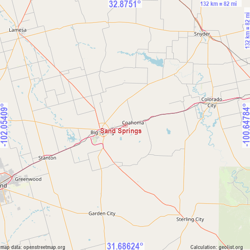
Sand Springs GPS coordinates[2]
32° 16' 57.432" North, 101° 21' 3.456" West
| Map corner | latitude | longitude |
|---|---|---|
| Upper-left | 32.8751°, | -102.05409° |
| Center: | 32.28262°, | -101.35096° |
| Lower-right: | 31.68624°, | -100.64784° |
| Map W x H: | 132.2×132.2 km | = 82.1×82.1mi |
| max Lat: | 71.29058° ⇑87.9% North |
| Sand Springs: | 32.28262° |
| min Lat: | ⇓12.1% South 19.06759° |
| min Long | Sand Springs | max Long |
| -171.73463° | -101.35096° | -66.98998° |
| W 18.5%⇐ | ⇒81.5% E |
Elevation
Elevation of Sand Springs is 740 m = 2428 ft, and this is 445.2 m = 1461 ft above average elevation for this country.
| Max E: |
3189 m = 10463 ft | 8.6% |
| Sand Springs | 740 m 2428 ft | |
| Avg. | 294.8 m = 967 ft | |
Min E: |
-60 m = -197 ft | 91.4% |
See also: United States elevation on elevation.city.
Geographical zone
Sand Springs is located in North temperate zone (between Tropic of Cancer and the Arctic Circle). Distance of this Northern Tropic circle is 983.6 km =611.2 mi to South.| Distance of | km | miles | from Sand Springs |
|---|---|---|---|
| North Pole | 6417.6 | 3987.7 | to North |
| Arctic Circle | 3811.7 | 2368.5 | to North |
| Tropic Cancer | 983.6 | 611.2 | to South |
| Equator | 3589.5 | 2230.4 | to South |


Nearby cities:
15 places around Sand Springs: (largest is in red/bold)
• Big Spring
12.5 km =7.8 mi,  253°
253°
• Coahoma
4.5 km =2.8 mi,  69°
69°
• Colorado City
47.2 km =29.3 mi,  75°
75°
• Gail
55 km =34.2 mi,  350°
350°
• Garden City
48.1 km =29.9 mi,  194°
194°
• Lamesa
75.7 km =47 mi,  311°
311°
• Loraine
61.7 km =38.3 mi, 76°
• Midland
75.4 km =46.9 mi, 245°
• O'Donnell
88.1 km =54.7 mi,  329°
329°
• Robert Lee
92.4 km =57.4 mi,  118°
118°
• Roscoe
78.4 km =48.7 mi, 76°
• Snyder
63.2 km =39.3 mi,  40°
40°
• Stanton
44.6 km =27.7 mi, 247°
• Sterling City
60.4 km =37.5 mi,  145°
145°
• Sweetwater
91.2 km =56.7 mi, 76°
Sources, notices
• [Note1] Compared only with cities in United States existing in our database
• [Src1] Map data: © OpenStreetMap contributors (CC-BY-SA)
• [Src2] Other city data from geonames.org with taken over terms of usage.
• [Src3] Geographical zone / Annual Mean Temperature by Robert A. Rohde @ Wikipedia
