Sweetwater geodata
Sweetwater (Texas) is a seat of a second-order administrative division; located in United States in America/Chicago (GMT-5) time zone. With population of 10,809 people, there are 4228 cities with bigger population in this country. Compared to other cities in United States, 87.2% of cities are located further ↑North; 80.9% of cities are located further →East and 90.5% of cities have lower elevation than Sweetwater. Note1


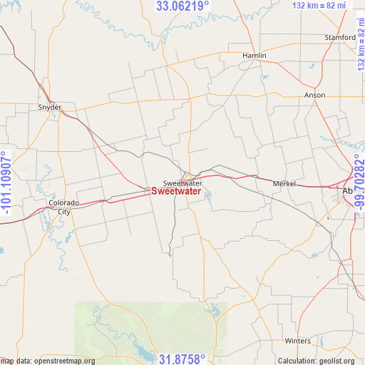
Sweetwater GPS coordinates[2]
32° 28' 15.42" North, 100° 24' 21.384" West
| Map corner | latitude | longitude |
|---|---|---|
| Upper-left | 33.06219°, | -101.10907° |
| Center: | 32.47095°, | -100.40594° |
| Lower-right: | 31.8758°, | -99.70282° |
| Map W x H: | 131.9×131.9 km | = 82×82mi |
| max Lat: | 71.29058° ⇑87.2% North |
| Sweetwater: | 32.47095° |
| min Lat: | ⇓12.8% South 19.06759° |
| min Long | Sweetwater | max Long |
| -171.73463° | -100.40594° | -66.98998° |
| W 19.1%⇐ | ⇒80.9% E |
Elevation
Elevation of Sweetwater is 664 m = 2178 ft, and this is 369.2 m = 1211 ft above average elevation for this country.
| Max E: |
3189 m = 10463 ft | 9.5% |
| Sweetwater | 664 m 2178 ft | |
| Avg. | 294.8 m = 967 ft | |
Min E: |
-60 m = -197 ft | 90.5% |
See also: United States elevation on elevation.city.
Geographical zone
Sweetwater is located in North temperate zone (between Tropic of Cancer and the Arctic Circle). Distance of this Northern Tropic circle is 1004.5 km =624.2 mi to South.| Distance of | km | miles | from Sweetwater |
|---|---|---|---|
| North Pole | 6396.6 | 3974.7 | to North |
| Arctic Circle | 3790.7 | 2355.4 | to North |
| Tropic Cancer | 1004.5 | 624.2 | to South |
| Equator | 3610.4 | 2243.4 | to South |


Nearby cities:
15 places around Sweetwater: (largest is in red/bold)
• Abilene
63.2 km =39.3 mi,  92°
92°
• Anson
57.3 km =35.6 mi,  56°
56°
• Bronte
65.8 km =40.9 mi,  170°
170°
• Colorado City
44 km =27.3 mi,  257°
257°
• Hamlin
52.9 km =32.9 mi,  29°
29°
• Hawley
57.6 km =35.8 mi,  74°
74°
• Loraine
29.5 km =18.3 mi, 256°
• Merkel
36.9 km =22.9 mi, 90°
• Robert Lee
64.8 km =40.3 mi,  186°
186°
• Roby
30.6 km =19 mi,  4°
4°
• Roscoe
12.8 km =8 mi, 257°
• Rotan
42.7 km =26.5 mi,  352°
352°
• Snyder
55.2 km =34.3 mi,  299°
299°
• Tuscola
64.2 km =39.9 mi,  116°
116°
• Tye
50.2 km =31.2 mi, 91°
Sources, notices
• [Note1] Compared only with cities in United States existing in our database
• [Src1] Map data: © OpenStreetMap contributors (CC-BY-SA)
• [Src2] Other city data from geonames.org with taken over terms of usage.
• [Src3] Geographical zone / Annual Mean Temperature by Robert A. Rohde @ Wikipedia
