Earth geodata
Earth (Texas) is a populated place; located in United States in America/Chicago (GMT-5) time zone. With population of 1,012 people, there are 16203 cities with bigger population in this country. Compared to other cities in United States, 78.8% of cities are located further ↑North; 82% of cities are located further →East and 94.2% of cities have lower elevation than Earth. Note1


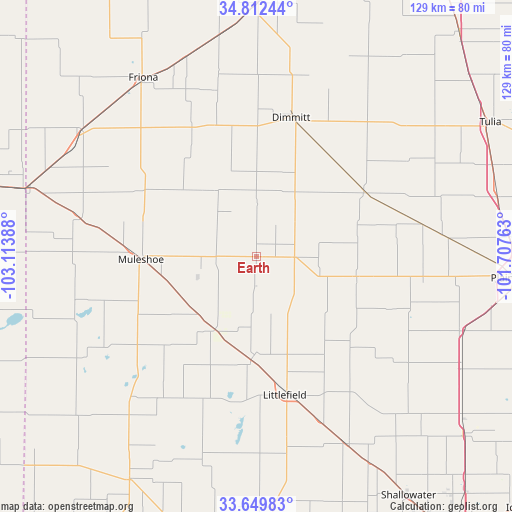
Earth GPS coordinates[2]
34° 13' 59.304" North, 102° 24' 38.7" West
| Map corner | latitude | longitude |
|---|---|---|
| Upper-left | 34.81244°, | -103.11388° |
| Center: | 34.23314°, | -102.41075° |
| Lower-right: | 33.64983°, | -101.70763° |
| Map W x H: | 129.3×129.3 km | = 80.3×80.3mi |
| max Lat: | 71.29058° ⇑78.8% North |
| Earth: | 34.23314° |
| min Lat: | ⇓21.2% South 19.06759° |
| min Long | Earth | max Long |
| -171.73463° | -102.41075° | -66.98998° |
| W 18%⇐ | ⇒82% E |
Elevation
Elevation of Earth is 1129 m = 3704 ft, and this is 834.2 m = 2737 ft above average elevation for this country.
| Max E: |
3189 m = 10463 ft | 5.8% |
| Earth | 1129 m 3704 ft | |
| Avg. | 294.8 m = 967 ft | |
Min E: |
-60 m = -197 ft | 94.2% |
See also: United States elevation on elevation.city.
Geographical zone
Earth is located in North temperate zone (between Tropic of Cancer and the Arctic Circle). Distance of this Northern Tropic circle is 1200.4 km =745.9 mi to South.| Distance of | km | miles | from Earth |
|---|---|---|---|
| North Pole | 6200.7 | 3852.9 | to North |
| Arctic Circle | 3594.8 | 2233.7 | to North |
| Tropic Cancer | 1200.4 | 745.9 | to South |
| Equator | 3806.4 | 2365.2 | to South |


Nearby cities:
15 places around Earth: (largest is in red/bold)
• Amherst
24.8 km =15.4 mi,  181°
181°
• Anton
52.1 km =32.4 mi,  154°
154°
• Bovina
53.4 km =33.2 mi,  305°
305°
• Dimmitt
36.5 km =22.7 mi,  14°
14°
• Farwell
60 km =37.3 mi,  286°
286°
• Friona
53.8 km =33.4 mi,  327°
327°
• Hale Center
55.4 km =34.4 mi,  109°
109°
• Hart
31.9 km =19.8 mi,  58°
58°
• Hereford
64.7 km =40.2 mi,  0°
0°
• Kress
62.6 km =38.9 mi,  76°
76°
• Littlefield
36 km =22.4 mi,  167°
167°
• Muleshoe
28.8 km =17.9 mi,  268°
268°
• Olton
26 km =16.2 mi,  102°
102°
• Sudan
21.1 km =13.1 mi,  209°
209°
• Texico
61.3 km =38.1 mi, 286°
Sources, notices
• [Note1] Compared only with cities in United States existing in our database
• [Src1] Map data: © OpenStreetMap contributors (CC-BY-SA)
• [Src2] Other city data from geonames.org with taken over terms of usage.
• [Src3] Geographical zone / Annual Mean Temperature by Robert A. Rohde @ Wikipedia
