Amherst geodata
Amherst (Texas) is a populated place; located in United States in America/Chicago (GMT-5) time zone. With population of 683 people, there are 18848 cities with bigger population in this country. Compared to other cities in United States, 80.2% of cities are located further ↑North; 82% of cities are located further →East and 94.1% of cities have lower elevation than Amherst. Note1


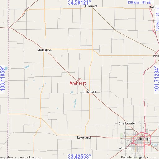
Amherst GPS coordinates[2]
34° 0' 37.332" North, 102° 24' 55.656" West
| Map corner | latitude | longitude |
|---|---|---|
| Upper-left | 34.59121°, | -103.11859° |
| Center: | 34.01037°, | -102.41546° |
| Lower-right: | 33.42553°, | -101.71234° |
| Map W x H: | 129.6×129.6 km | = 80.5×80.5mi |
| max Lat: | 71.29058° ⇑80.2% North |
| Amherst: | 34.01037° |
| min Lat: | ⇓19.8% South 19.06759° |
| min Long | Amherst | max Long |
| -171.73463° | -102.41546° | -66.98998° |
| W 18%⇐ | ⇒82% E |
Elevation
Elevation of Amherst is 1113 m = 3652 ft, and this is 818.2 m = 2684 ft above average elevation for this country.
| Max E: |
3189 m = 10463 ft | 5.9% |
| Amherst | 1113 m 3652 ft | |
| Avg. | 294.8 m = 967 ft | |
Min E: |
-60 m = -197 ft | 94.1% |
See also: United States elevation on elevation.city.
Geographical zone
Amherst is located in North temperate zone (between Tropic of Cancer and the Arctic Circle). Distance of this Northern Tropic circle is 1175.7 km =730.5 mi to South.| Distance of | km | miles | from Amherst |
|---|---|---|---|
| North Pole | 6225.5 | 3868.3 | to North |
| Arctic Circle | 3619.6 | 2249.1 | to North |
| Tropic Cancer | 1175.7 | 730.5 | to South |
| Equator | 3781.6 | 2349.8 | to South |


Nearby cities:
15 places around Amherst: (largest is in red/bold)
• Abernathy
56.4 km =35 mi,  110°
110°
• Anton
32.1 km =19.9 mi,  133°
133°
• Dimmitt
60.9 km =37.8 mi,  8°
8°
• Earth
24.8 km =15.4 mi,  1°
1°
• Hale Center
53 km =32.9 mi,  83°
83°
• Hart
50 km =31.1 mi,  33°
33°
• Levelland
47.2 km =29.3 mi,  175°
175°
• Littlefield
13.3 km =8.3 mi,  141°
141°
• Morton
44.9 km =27.9 mi,  225°
225°
• Muleshoe
37.2 km =23.1 mi,  310°
310°
• New Deal
61.5 km =38.2 mi,  119°
119°
• Olton
32.2 km =20 mi,  53°
53°
• Shallowater
52.6 km =32.7 mi, 132°
• Sudan
11.9 km =7.4 mi,  302°
302°
• Sundown
62 km =38.5 mi,  186°
186°
Sources, notices
• [Note1] Compared only with cities in United States existing in our database
• [Src1] Map data: © OpenStreetMap contributors (CC-BY-SA)
• [Src2] Other city data from geonames.org with taken over terms of usage.
• [Src3] Geographical zone / Annual Mean Temperature by Robert A. Rohde @ Wikipedia
