Jal geodata
Jal (New Mexico) is a populated place; located in United States in America/Denver (GMT-6) time zone. With population of 2,201 people, there are 11340 cities with bigger population in this country. Compared to other cities in United States, 88.3% of cities are located further ↑North; 82.3% of cities are located further →East and 93% of cities have lower elevation than Jal. Note1


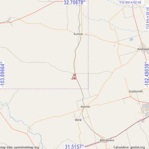
Jal GPS coordinates[2]
32° 6' 47.448" North, 103° 11' 36.636" West
| Map corner | latitude | longitude |
|---|---|---|
| Upper-left | 32.70678°, | -103.89664° |
| Center: | 32.11318°, | -103.19351° |
| Lower-right: | 31.5157°, | -102.49039° |
| Map W x H: | 132.4×132.4 km | = 82.3×82.3mi |
| max Lat: | 71.29058° ⇑88.3% North |
| Jal: | 32.11318° |
| min Lat: | ⇓11.7% South 19.06759° |
| min Long | Jal | max Long |
| -171.73463° | -103.19351° | -66.98998° |
| W 17.7%⇐ | ⇒82.3% E |
Elevation
Elevation of Jal is 939 m = 3081 ft, and this is 644.2 m = 2114 ft above average elevation for this country.
| Max E: |
3189 m = 10463 ft | 7% |
| Jal | 939 m 3081 ft | |
| Avg. | 294.8 m = 967 ft | |
Min E: |
-60 m = -197 ft | 93% |
See also: United States elevation on elevation.city.
Geographical zone
Jal is located in North temperate zone (between Tropic of Cancer and the Arctic Circle). Distance of this Northern Tropic circle is 964.7 km =599.4 mi to South.| Distance of | km | miles | from Jal |
|---|---|---|---|
| North Pole | 6436.4 | 3999.4 | to North |
| Arctic Circle | 3830.5 | 2380.2 | to North |
| Tropic Cancer | 964.7 | 599.4 | to South |
| Equator | 3570.7 | 2218.7 | to South |


Nearby cities:
15 places around Jal: (largest is in red/bold)
• Andrews
65.1 km =40.5 mi,  69°
69°
• Eunice
36.2 km =22.5 mi,  5°
5°
• Gardendale
77.3 km =48 mi,  97°
97°
• Hobbs
65.8 km =40.9 mi,  4°
4°
• Kermit
30 km =18.6 mi,  161°
161°
• McKinney Acres
65.9 km =40.9 mi, 71°
• Mentone
59.4 km =36.9 mi,  220°
220°
• Monahans
64.3 km =40 mi,  153°
153°
• Odessa
83.4 km =51.8 mi,  110°
110°
• Pecos
81.8 km =50.8 mi,  200°
200°
• Seminole
84.8 km =52.7 mi,  37°
37°
• Thorntonville
64.3 km =40 mi, 156°
• West Odessa
72.1 km =44.8 mi, 114°
• Wickett
63.1 km =39.2 mi, 163°
• Wink
40.4 km =25.1 mi,  175°
175°
Sources, notices
• [Note1] Compared only with cities in United States existing in our database
• [Src1] Map data: © OpenStreetMap contributors (CC-BY-SA)
• [Src2] Other city data from geonames.org with taken over terms of usage.
• [Src3] Geographical zone / Annual Mean Temperature by Robert A. Rohde @ Wikipedia
