Loving geodata
Loving (New Mexico) is a populated place; located in United States in America/Denver (GMT-6) time zone. With population of 1,409 people, there are 14068 cities with bigger population in this country. Compared to other cities in United States, 87.9% of cities are located further ↑North; 82.7% of cities are located further →East and 93% of cities have lower elevation than Loving. Note1


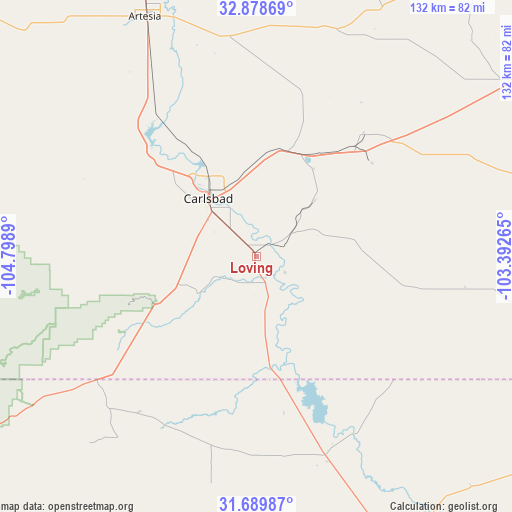
Loving GPS coordinates[2]
32° 17' 10.428" North, 104° 5' 44.772" West
| Map corner | latitude | longitude |
|---|---|---|
| Upper-left | 32.87869°, | -104.7989° |
| Center: | 32.28623°, | -104.09577° |
| Lower-right: | 31.68987°, | -103.39265° |
| Map W x H: | 132.2×132.2 km | = 82.1×82.1mi |
| max Lat: | 71.29058° ⇑87.9% North |
| Loving: | 32.28623° |
| min Lat: | ⇓12.1% South 19.06759° |
| min Long | Loving | max Long |
| -171.73463° | -104.09577° | -66.98998° |
| W 17.3%⇐ | ⇒82.7% E |
Elevation
Elevation of Loving is 933 m = 3061 ft, and this is 638.2 m = 2094 ft above average elevation for this country.
| Max E: |
3189 m = 10463 ft | 7% |
| Loving | 933 m 3061 ft | |
| Avg. | 294.8 m = 967 ft | |
Min E: |
-60 m = -197 ft | 93% |
See also: United States elevation on elevation.city.
Geographical zone
Loving is located in North temperate zone (between Tropic of Cancer and the Arctic Circle). Distance of this Northern Tropic circle is 984 km =611.4 mi to South.| Distance of | km | miles | from Loving |
|---|---|---|---|
| North Pole | 6417.2 | 3987.5 | to North |
| Arctic Circle | 3811.3 | 2368.2 | to North |
| Tropic Cancer | 984 | 611.4 | to South |
| Equator | 3589.9 | 2230.7 | to South |


Nearby cities:
15 places around Loving: (largest is in red/bold)
• Artesia
68.2 km =42.4 mi,  335°
335°
• Atoka
60.4 km =37.5 mi,  332°
332°
• Carlsbad
19.5 km =12.1 mi,  320°
320°
• Dexter
104.6 km =65 mi,  345°
345°
• Eunice
89.6 km =55.7 mi,  79°
79°
• Hagerman
94.7 km =58.8 mi, 346°
• Hobbs
101.2 km =62.9 mi,  62°
62°
• Jal
87 km =54.1 mi,  102°
102°
• Kermit
105.8 km =65.7 mi,  116°
116°
• La Huerta
21 km =13 mi, 325°
• Livingston Wheeler
15.4 km =9.6 mi, 319°
• Lovington
101.2 km =62.9 mi,  43°
43°
• Mentone
79.8 km =49.6 mi,  144°
144°
• Pecos
111.6 km =69.3 mi,  149°
149°
• Wink
106.4 km =66.1 mi, 123°
Sources, notices
• [Note1] Compared only with cities in United States existing in our database
• [Src1] Map data: © OpenStreetMap contributors (CC-BY-SA)
• [Src2] Other city data from geonames.org with taken over terms of usage.
• [Src3] Geographical zone / Annual Mean Temperature by Robert A. Rohde @ Wikipedia
