Odessa geodata
Odessa (Texas) is a seat of a second-order administrative division; located in United States in America/Chicago (GMT-5) time zone. With population of 118,968 people, there are 265 cities with bigger population in this country. Compared to other cities in United States, 88.9% of cities are located further ↑North; 82% of cities are located further →East and 92.6% of cities have lower elevation than Odessa. Note1


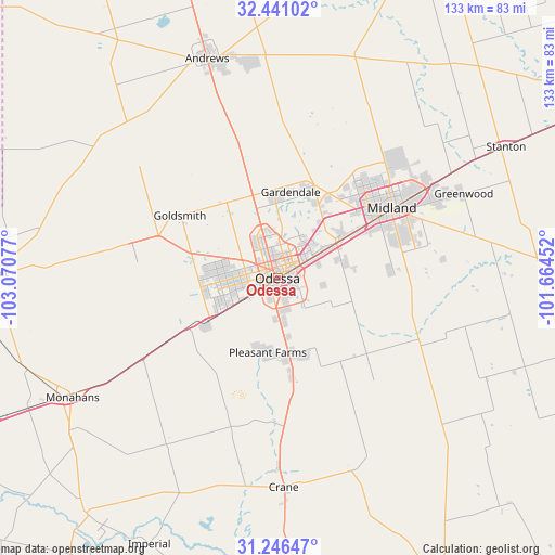
Odessa GPS coordinates[2]
31° 50' 44.448" North, 102° 22' 3.504" West
| Map corner | latitude | longitude |
|---|---|---|
| Upper-left | 32.44102°, | -103.07077° |
| Center: | 31.84568°, | -102.36764° |
| Lower-right: | 31.24647°, | -101.66452° |
| Map W x H: | 132.8×132.8 km | = 82.5×82.5mi |
| max Lat: | 71.29058° ⇑88.9% North |
| Odessa: | 31.84568° |
| min Lat: | ⇓11.1% South 19.06759° |
| min Long | Odessa | max Long |
| -171.73463° | -102.36764° | -66.98998° |
| W 18%⇐ | ⇒82% E |
Elevation
Elevation of Odessa is 885 m = 2904 ft, and this is 590.2 m = 1936 ft above average elevation for this country.
| Max E: |
3189 m = 10463 ft | 7.4% |
| Odessa | 885 m 2904 ft | |
| Avg. | 294.8 m = 967 ft | |
Min E: |
-60 m = -197 ft | 92.6% |
See also: Odessa elevation on elevation.city.
Geographical zone
Odessa is located in North temperate zone (between Tropic of Cancer and the Arctic Circle). Distance of this Northern Tropic circle is 935 km =581 mi to South.| Distance of | km | miles | from Odessa |
|---|---|---|---|
| North Pole | 6466.2 | 4017.9 | to North |
| Arctic Circle | 3860.3 | 2398.7 | to North |
| Tropic Cancer | 935 | 581 | to South |
| Equator | 3540.9 | 2200.2 | to South |


Nearby cities:
15 places around Odessa: (largest is in red/bold)
• Andrews
55.2 km =34.3 mi,  342°
342°
• Crane
49.9 km =31 mi,  178°
178°
• Gardendale
19.5 km =12.1 mi,  356°
356°
• Jal
83.4 km =51.8 mi,  290°
290°
• Kermit
68.5 km =42.6 mi,  271°
271°
• McCamey
80.1 km =49.8 mi,  170°
170°
• McKinney Acres
53 km =32.9 mi, 343°
• Midland
32.1 km =19.9 mi,  58°
58°
• Monahans
57 km =35.4 mi,  240°
240°
• Rankin
80.4 km =50 mi,  149°
149°
• Stanton
63.1 km =39.2 mi, 60°
• Thorntonville
59.9 km =37.2 mi, 240°
• West Odessa
12.4 km =7.7 mi, 268°
• Wickett
67.3 km =41.8 mi, 242°
• Wink
75.6 km =47 mi,  262°
262°
Sources, notices
• [Note1] Compared only with cities in United States existing in our database
• [Src1] Map data: © OpenStreetMap contributors (CC-BY-SA)
• [Src2] Other city data from geonames.org with taken over terms of usage.
• [Src3] Geographical zone / Annual Mean Temperature by Robert A. Rohde @ Wikipedia
