Channing geodata
Channing (Texas) is a seat of a second-order administrative division; located in United States in America/Chicago (GMT-5) time zone. With population of 360 people, there are 20953 cities with bigger population in this country. Compared to other cities in United States, 71.8% of cities are located further ↑North; 82% of cities are located further →East and 94.4% of cities have lower elevation than Channing. Note1


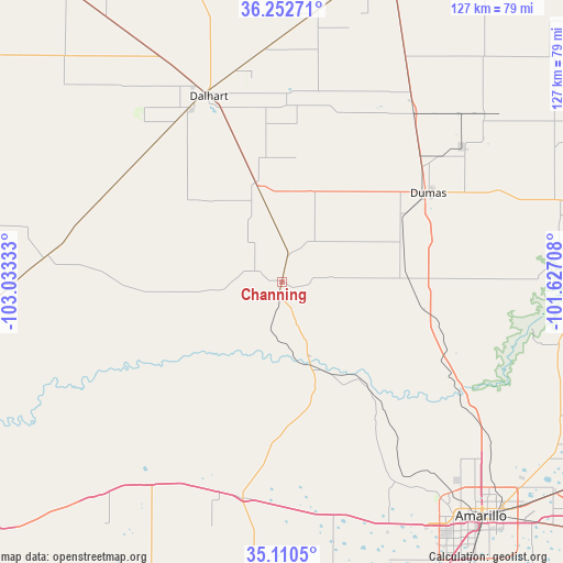
Channing GPS coordinates[2]
35° 41' 1.14" North, 102° 19' 48.72" West
| Map corner | latitude | longitude |
|---|---|---|
| Upper-left | 36.25271°, | -103.03333° |
| Center: | 35.68365°, | -102.3302° |
| Lower-right: | 35.1105°, | -101.62708° |
| Map W x H: | 127×127 km | = 78.9×78.9mi |
| max Lat: | 71.29058° ⇑71.8% North |
| Channing: | 35.68365° |
| min Lat: | ⇓28.2% South 19.06759° |
| min Long | Channing | max Long |
| -171.73463° | -102.3302° | -66.98998° |
| W 18%⇐ | ⇒82% E |
Elevation
Elevation of Channing is 1161 m = 3809 ft, and this is 866.2 m = 2842 ft above average elevation for this country.
| Max E: |
3189 m = 10463 ft | 5.6% |
| Channing | 1161 m 3809 ft | |
| Avg. | 294.8 m = 967 ft | |
Min E: |
-60 m = -197 ft | 94.4% |
See also: United States elevation on elevation.city.
Geographical zone
Channing is located in North temperate zone (between Tropic of Cancer and the Arctic Circle). Distance of this Northern Tropic circle is 1361.7 km =846.1 mi to South.| Distance of | km | miles | from Channing |
|---|---|---|---|
| North Pole | 6039.4 | 3752.7 | to North |
| Arctic Circle | 3433.5 | 2133.5 | to North |
| Tropic Cancer | 1361.7 | 846.1 | to South |
| Equator | 3967.6 | 2465.4 | to South |


Nearby cities:
15 places around Channing: (largest is in red/bold)
• Amarillo
68.4 km =42.5 mi,  138°
138°
• Borger
84.3 km =52.4 mi,  91°
91°
• Bushland
59.7 km =37.1 mi,  156°
156°
• Cactus
50.5 km =31.4 mi,  35°
35°
• Canyon
86.6 km =53.8 mi,  154°
154°
• Dalhart
44.9 km =27.9 mi,  338°
338°
• Dumas
38 km =23.6 mi,  57°
57°
• Fritch
65.9 km =40.9 mi, 94°
• Hartley
23.2 km =14.4 mi,  345°
345°
• Lake Tanglewood
84.4 km =52.4 mi, 144°
• Panhandle
93.8 km =58.3 mi,  113°
113°
• Stinnett
81.6 km =50.7 mi,  78°
78°
• Stratford
76.2 km =47.3 mi,  17°
17°
• Sunray
58.7 km =36.5 mi,  50°
50°
• Vega
49.8 km =30.9 mi,  190°
190°
Sources, notices
• [Note1] Compared only with cities in United States existing in our database
• [Src1] Map data: © OpenStreetMap contributors (CC-BY-SA)
• [Src2] Other city data from geonames.org with taken over terms of usage.
• [Src3] Geographical zone / Annual Mean Temperature by Robert A. Rohde @ Wikipedia
