Hartley geodata
Hartley (Texas) is a populated place; located in United States in America/Chicago (GMT-5) time zone. With population of 540 people, there are 20388 cities with bigger population in this country. Compared to other cities in United States, 71% of cities are located further ↑North; 82% of cities are located further →East and 94.5% of cities have lower elevation than Hartley. Note1


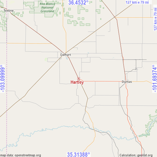
Hartley GPS coordinates[2]
35° 53' 8.124" North, 102° 23' 48.696" West
| Map corner | latitude | longitude |
|---|---|---|
| Upper-left | 36.4532°, | -103.09999° |
| Center: | 35.88559°, | -102.39686° |
| Lower-right: | 35.31388°, | -101.69374° |
| Map W x H: | 126.7×126.7 km | = 78.7×78.7mi |
| max Lat: | 71.29058° ⇑71% North |
| Hartley: | 35.88559° |
| min Lat: | ⇓29% South 19.06759° |
| min Long | Hartley | max Long |
| -171.73463° | -102.39686° | -66.98998° |
| W 18%⇐ | ⇒82% E |
Elevation
Elevation of Hartley is 1194 m = 3917 ft, and this is 899.2 m = 2950 ft above average elevation for this country.
| Max E: |
3189 m = 10463 ft | 5.5% |
| Hartley | 1194 m 3917 ft | |
| Avg. | 294.8 m = 967 ft | |
Min E: |
-60 m = -197 ft | 94.5% |
See also: United States elevation on elevation.city.
Geographical zone
Hartley is located in North temperate zone (between Tropic of Cancer and the Arctic Circle). Distance of this Northern Tropic circle is 1384.2 km =860.1 mi to South.| Distance of | km | miles | from Hartley |
|---|---|---|---|
| North Pole | 6017 | 3738.8 | to North |
| Arctic Circle | 3411.1 | 2119.6 | to North |
| Tropic Cancer | 1384.2 | 860.1 | to South |
| Equator | 3990.1 | 2479.3 | to South |


Nearby cities:
15 places around Hartley: (largest is in red/bold)
• Amarillo
89.8 km =55.8 mi,  145°
145°
• Boise City
94.4 km =58.7 mi,  353°
353°
• Borger
93.4 km =58 mi,  105°
105°
• Bushland
82.8 km =51.4 mi,  158°
158°
• Cactus
40 km =24.9 mi,  62°
62°
• Channing
23.2 km =14.4 mi,  165°
165°
• Dalhart
22 km =13.7 mi,  331°
331°
• Dumas
38.2 km =23.7 mi,  93°
93°
• Fritch
76.6 km =47.6 mi, 110°
• Stinnett
86.2 km =53.6 mi, 94°
• Stratford
58 km =36 mi,  30°
30°
• Sunray
53.5 km =33.2 mi,  74°
74°
• Texhoma
88.2 km =54.8 mi,  38°
38°
• Texline
78.5 km =48.8 mi,  314°
314°
• Vega
71.5 km =44.4 mi,  182°
182°
Sources, notices
• [Note1] Compared only with cities in United States existing in our database
• [Src1] Map data: © OpenStreetMap contributors (CC-BY-SA)
• [Src2] Other city data from geonames.org with taken over terms of usage.
• [Src3] Geographical zone / Annual Mean Temperature by Robert A. Rohde @ Wikipedia
