Texline geodata
Texline (Texas) is a populated place; located in United States in America/Chicago (GMT-5) time zone. With population of 525 people, there are 20573 cities with bigger population in this country. Compared to other cities in United States, 68.6% of cities are located further ↑North; 82.3% of cities are located further →East and 96.2% of cities have lower elevation than Texline. Note1


Texline GPS coordinates[2]
36° 22' 40.116" North, 103° 1' 26.76" West
| Map corner | latitude | longitude |
|---|---|---|
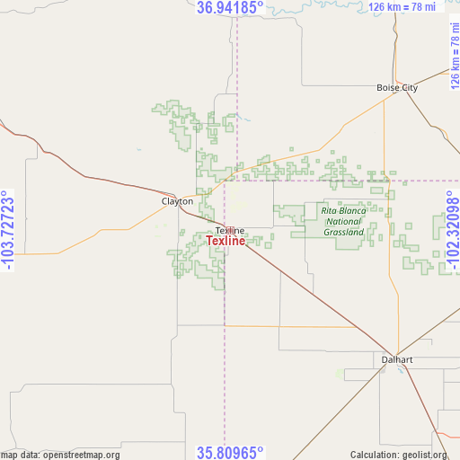
| Upper-left | 36.94185°, | -103.72723° |
| Center: | 36.37781°, | -103.0241° |
| Lower-right: | 35.80965°, | -102.32098° |
| Map W x H: | 125.9×125.9 km | = 78.2×78.2mi |
| max Lat: | 71.29058° ⇑68.6% North |
| Texline: | 36.37781° |
| min Lat: | ⇓31.4% South 19.06759° |
| min Long | Texline | max Long |
| -171.73463° | -103.0241° | -66.98998° |
| W 17.7%⇐ | ⇒82.3% E |
Elevation
Elevation of Texline is 1431 m = 4695 ft, and this is 1136.2 m = 3728 ft above average elevation for this country.
| Max E: |
3189 m = 10463 ft | 3.8% |
| Texline | 1431 m 4695 ft | |
| Avg. | 294.8 m = 967 ft | |
Min E: |
-60 m = -197 ft | 96.2% |
See also: United States elevation on elevation.city.
Geographical zone
Texline is located in North temperate zone (between Tropic of Cancer and the Arctic Circle). Distance of this Northern Tropic circle is 1438.9 km =894.1 mi to South.| Distance of | km | miles | from Texline |
|---|---|---|---|
| North Pole | 5962.2 | 3704.7 | to North |
| Arctic Circle | 3356.3 | 2085.5 | to North |
| Tropic Cancer | 1438.9 | 894.1 | to South |
| Equator | 4044.8 | 2513.3 | to South |


Nearby cities:
15 places around Texline: (largest is in red/bold)
• Boise City
60.1 km =37.3 mi,  49°
49°
• Cactus
98.5 km =61.2 mi,  111°
111°
• Channing
99.2 km =61.6 mi,  141°
141°
• Clayton
16.5 km =10.3 mi,  299°
299°
• Dalhart
57.9 km =36 mi,  127°
127°
• Dumas
110.2 km =68.5 mi,  121°
121°
• Elkhart
123 km =76.4 mi,  55°
55°
• Goodwell
126.4 km =78.5 mi,  78°
78°
• Hartley
78.5 km =48.8 mi, 134°
• Logan
117.8 km =73.2 mi,  197°
197°
• Mosquero
107.2 km =66.6 mi,  231°
231°
• Springfield
120.2 km =74.7 mi,  17°
17°
• Stratford
85.4 km =53.1 mi,  93°
93°
• Sunray
114.9 km =71.4 mi, 110°
• Texhoma
111.9 km =69.5 mi, 82°
Sources, notices
• [Note1] Compared only with cities in United States existing in our database
• [Src1] Map data: © OpenStreetMap contributors (CC-BY-SA)
• [Src2] Other city data from geonames.org with taken over terms of usage.
• [Src3] Geographical zone / Annual Mean Temperature by Robert A. Rohde @ Wikipedia
