Mesquite geodata
Mesquite (Nevada) is a populated place; located in United States in America/Los_Angeles (GMT-7) time zone. With population of 17,496 people, there are 2847 cities with bigger population in this country. Compared to other cities in United States, 66.9% of cities are located further ↑North; 88.5% of cities are located further →East and 87.7% of cities have lower elevation than Mesquite. Note1


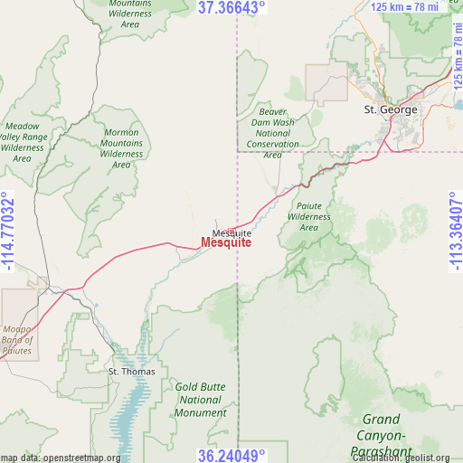
Mesquite GPS coordinates[2]
36° 48' 19.908" North, 114° 4' 1.884" West
| Map corner | latitude | longitude |
|---|---|---|
| Upper-left | 37.36643°, | -114.77032° |
| Center: | 36.80553°, | -114.06719° |
| Lower-right: | 36.24049°, | -113.36407° |
| Map W x H: | 125.2×125.2 km | = 77.8×77.8mi |
| max Lat: | 71.29058° ⇑66.9% North |
| Mesquite: | 36.80553° |
| min Lat: | ⇓33.1% South 19.06759° |
| min Long | Mesquite | max Long |
| -171.73463° | -114.06719° | -66.98998° |
| W 11.5%⇐ | ⇒88.5% E |
Elevation
Elevation of Mesquite is 493 m = 1617 ft, and this is 198.2 m = 650 ft above average elevation for this country.
| Max E: |
3189 m = 10463 ft | 12.3% |
| Mesquite | 493 m 1617 ft | |
| Avg. | 294.8 m = 967 ft | |
Min E: |
-60 m = -197 ft | 87.7% |
See also: United States elevation on elevation.city.
Geographical zone
Mesquite is located in North temperate zone (between Tropic of Cancer and the Arctic Circle). Distance of this Northern Tropic circle is 1486.5 km =923.7 mi to South.| Distance of | km | miles | from Mesquite |
|---|---|---|---|
| North Pole | 5914.7 | 3675.2 | to North |
| Arctic Circle | 3308.8 | 2056 | to North |
| Tropic Cancer | 1486.5 | 923.7 | to South |
| Equator | 4092.4 | 2542.9 | to South |


Nearby cities:
15 places around Mesquite: (largest is in red/bold)
• Beaver Dam
15.9 km =9.9 mi,  48°
48°
• Bunkerville
6.5 km =4 mi,  236°
236°
• Central
78.5 km =48.8 mi,  30°
30°
• Dammeron Valley
65.8 km =40.9 mi, 32°
• Hurricane
80.3 km =49.9 mi,  59°
59°
• Ivins
53.1 km =33 mi,  40°
40°
• LaVerkin
83.4 km =51.8 mi, 58°
• Leeds
79.2 km =49.2 mi, 52°
• Moapa Town
48.9 km =30.4 mi,  253°
253°
• Moapa Valley
43.8 km =27.2 mi, 235°
• Saint George
54.3 km =33.7 mi, 52°
• Santa Clara
51.7 km =32.1 mi, 45°
• Scenic
5 km =3.1 mi,  105°
105°
• Toquerville
85.5 km =53.1 mi, 54°
• Washington
61.4 km =38.2 mi, 53°
Sources, notices
• [Note1] Compared only with cities in United States existing in our database
• [Src1] Map data: © OpenStreetMap contributors (CC-BY-SA)
• [Src2] Other city data from geonames.org with taken over terms of usage.
• [Src3] Geographical zone / Annual Mean Temperature by Robert A. Rohde @ Wikipedia
