Wilton geodata
Wilton (North Dakota) is a populated place; located in United States in America/Chicago (GMT-5) time zone. With population of 725 people, there are 18450 cities with bigger population in this country. Compared to other cities in United States, 96.9% of cities are located further ↓South; 81.2% of cities are located further →East and 90.5% of cities have lower elevation than Wilton. Note1


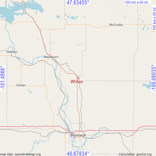
Wilton GPS coordinates[2]
47° 9' 30.96" North, 100° 47' 0.492" West
| Map corner | latitude | longitude |
|---|---|---|
| Upper-left | 47.63455°, | -101.4866° |
| Center: | 47.1586°, | -100.78347° |
| Lower-right: | 46.67834°, | -100.08035° |
| Map W x H: | 106.3×106.3 km | = 66.1×66.1mi |
| max Lat: | 71.29058° ⇑3.1% North |
| Wilton: | 47.1586° |
| min Lat: | ⇓96.9% South 19.06759° |
| min Long | Wilton | max Long |
| -171.73463° | -100.78347° | -66.98998° |
| W 18.8%⇐ | ⇒81.2% E |
Elevation
Elevation of Wilton is 662 m = 2172 ft, and this is 367.2 m = 1205 ft above average elevation for this country.
| Max E: |
3189 m = 10463 ft | 9.5% |
| Wilton | 662 m 2172 ft | |
| Avg. | 294.8 m = 967 ft | |
Min E: |
-60 m = -197 ft | 90.5% |
See also: United States elevation on elevation.city.
Geographical zone
Wilton is located in North temperate zone (between Tropic of Cancer and the Arctic Circle). Distance of this North polar circle is 2157.6 km =1340.7 mi to North.| Distance of | km | miles | from Wilton |
|---|---|---|---|
| North Pole | 4763.5 | 2959.9 | to North |
| Arctic Circle | 2157.6 | 1340.7 | to North |
| Tropic Cancer | 2637.6 | 1638.9 | to South |
| Equator | 5243.5 | 3258.2 | to South |


Nearby cities:
15 places around Wilton: (largest is in red/bold)
• Beulah
76 km =47.2 mi,  278°
278°
• Bismarck
38.9 km =24.2 mi,  180°
180°
• Cannon Ball
86.7 km =53.9 mi,  170°
170°
• Center
39.3 km =24.4 mi,  263°
263°
• Garrison
72.6 km =45.1 mi,  319°
319°
• Hazen
65.1 km =40.5 mi, 283°
• Lincoln
44.5 km =27.7 mi, 171°
• Mandan
37.8 km =23.5 mi,  192°
192°
• McClusky
44.5 km =27.7 mi,  35°
35°
• New Salem
59 km =36.7 mi,  233°
233°
• Stanton
48.6 km =30.2 mi,  291°
291°
• Steele
73.9 km =45.9 mi,  117°
117°
• Turtle Lake
41 km =25.5 mi,  348°
348°
• Underwood
42.5 km =26.4 mi, 321°
• Washburn
23.5 km =14.6 mi,  308°
308°
Sources, notices
• [Note1] Compared only with cities in United States existing in our database
• [Src1] Map data: © OpenStreetMap contributors (CC-BY-SA)
• [Src2] Other city data from geonames.org with taken over terms of usage.
• [Src3] Geographical zone / Annual Mean Temperature by Robert A. Rohde @ Wikipedia
