Garrison geodata
Garrison (North Dakota) is a populated place; located in United States in America/Chicago (GMT-5) time zone. With population of 1,538 people, there are 13523 cities with bigger population in this country. Compared to other cities in United States, 98% of cities are located further ↓South; 81.5% of cities are located further →East and 89.5% of cities have lower elevation than Garrison. Note1


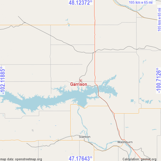
Garrison GPS coordinates[2]
47° 39' 7.992" North, 101° 24' 56.592" West
| Map corner | latitude | longitude |
|---|---|---|
| Upper-left | 48.12372°, | -102.11885° |
| Center: | 47.65222°, | -101.41572° |
| Lower-right: | 47.17643°, | -100.7126° |
| Map W x H: | 105.3×105.3 km | = 65.4×65.4mi |
| max Lat: | 71.29058° ⇑2% North |
| Garrison: | 47.65222° |
| min Lat: | ⇓98% South 19.06759° |
| min Long | Garrison | max Long |
| -171.73463° | -101.41572° | -66.98998° |
| W 18.5%⇐ | ⇒81.5% E |
Elevation
Elevation of Garrison is 589 m = 1932 ft, and this is 294.2 m = 965 ft above average elevation for this country.
| Max E: |
3189 m = 10463 ft | 10.5% |
| Garrison | 589 m 1932 ft | |
| Avg. | 294.8 m = 967 ft | |
Min E: |
-60 m = -197 ft | 89.5% |
See also: United States elevation on elevation.city.
Geographical zone
Garrison is located in North temperate zone (between Tropic of Cancer and the Arctic Circle). Distance of this North polar circle is 2102.7 km =1306.6 mi to North.| Distance of | km | miles | from Garrison |
|---|---|---|---|
| North Pole | 4708.6 | 2925.8 | to North |
| Arctic Circle | 2102.7 | 1306.6 | to North |
| Tropic Cancer | 2692.5 | 1673 | to South |
| Equator | 5298.4 | 3292.3 | to South |


Nearby cities:
15 places around Garrison: (largest is in red/bold)
• Berthold
77.3 km =48 mi,  341°
341°
• Beulah
51.1 km =31.8 mi,  212°
212°
• Burlington
69.3 km =43.1 mi,  359°
359°
• Center
60.2 km =37.4 mi,  171°
171°
• Hazen
42.7 km =26.5 mi,  201°
201°
• McClusky
75.3 km =46.8 mi,  104°
104°
• Minot
65.1 km =40.5 mi,  7°
7°
• Parshall
63.3 km =39.3 mi,  301°
301°
• Stanton
36.9 km =22.9 mi,  176°
176°
• Surrey
68.3 km =42.4 mi,  17°
17°
• Turtle Lake
42.1 km =26.2 mi,  110°
110°
• Underwood
30.2 km =18.8 mi,  136°
136°
• Velva
57.7 km =35.9 mi,  38°
38°
• Washburn
49.7 km =30.9 mi, 144°
• Wilton
72.6 km =45.1 mi, 139°
Sources, notices
• [Note1] Compared only with cities in United States existing in our database
• [Src1] Map data: © OpenStreetMap contributors (CC-BY-SA)
• [Src2] Other city data from geonames.org with taken over terms of usage.
• [Src3] Geographical zone / Annual Mean Temperature by Robert A. Rohde @ Wikipedia
