Washburn geodata
Washburn (North Dakota) is a seat of a second-order administrative division; located in United States in America/Chicago (GMT-5) time zone. With population of 1,309 people, there are 14549 cities with bigger population in this country. Compared to other cities in United States, 97.1% of cities are located further ↓South; 81.4% of cities are located further →East and 88.6% of cities have lower elevation than Washburn. Note1


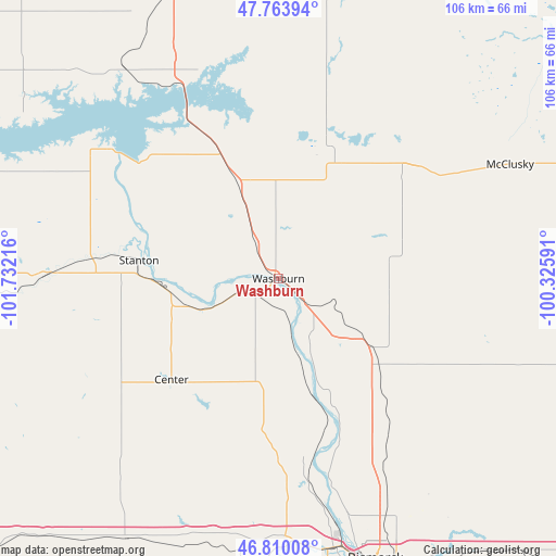
Washburn GPS coordinates[2]
47° 17' 20.976" North, 101° 1' 44.508" West
| Map corner | latitude | longitude |
|---|---|---|
| Upper-left | 47.76394°, | -101.73216° |
| Center: | 47.28916°, | -101.02903° |
| Lower-right: | 46.81008°, | -100.32591° |
| Map W x H: | 106.1×106.1 km | = 65.9×65.9mi |
| max Lat: | 71.29058° ⇑2.9% North |
| Washburn: | 47.28916° |
| min Lat: | ⇓97.1% South 19.06759° |
| min Long | Washburn | max Long |
| -171.73463° | -101.02903° | -66.98998° |
| W 18.6%⇐ | ⇒81.4% E |
Elevation
Elevation of Washburn is 534 m = 1752 ft, and this is 239.2 m = 785 ft above average elevation for this country.
| Max E: |
3189 m = 10463 ft | 11.4% |
| Washburn | 534 m 1752 ft | |
| Avg. | 294.8 m = 967 ft | |
Min E: |
-60 m = -197 ft | 88.6% |
See also: United States elevation on elevation.city.
Geographical zone
Washburn is located in North temperate zone (between Tropic of Cancer and the Arctic Circle). Distance of this North polar circle is 2143.1 km =1331.7 mi to North.| Distance of | km | miles | from Washburn |
|---|---|---|---|
| North Pole | 4749 | 2950.9 | to North |
| Arctic Circle | 2143.1 | 1331.7 | to North |
| Tropic Cancer | 2652.1 | 1647.9 | to South |
| Equator | 5258.1 | 3267.2 | to South |


Nearby cities:
15 places around Washburn: (largest is in red/bold)
• Beulah
56.6 km =35.2 mi,  267°
267°
• Bismarck
56.6 km =35.2 mi,  160°
160°
• Center
28.1 km =17.5 mi,  226°
226°
• Garrison
49.7 km =30.9 mi,  324°
324°
• Glen Ullin
80.4 km =50 mi, 229°
• Hazen
44.8 km =27.8 mi, 270°
• Lincoln
63.6 km =39.5 mi, 156°
• Mandan
52.5 km =32.6 mi,  168°
168°
• McClusky
49.2 km =30.6 mi,  63°
63°
• New Salem
57.2 km =35.5 mi,  210°
210°
• Stanton
26.8 km =16.7 mi,  277°
277°
• Turtle Lake
27.7 km =17.2 mi,  22°
22°
• Underwood
20.3 km =12.6 mi,  336°
336°
• Velva
85.6 km =53.2 mi,  5°
5°
• Wilton
23.5 km =14.6 mi,  128°
128°
Sources, notices
• [Note1] Compared only with cities in United States existing in our database
• [Src1] Map data: © OpenStreetMap contributors (CC-BY-SA)
• [Src2] Other city data from geonames.org with taken over terms of usage.
• [Src3] Geographical zone / Annual Mean Temperature by Robert A. Rohde @ Wikipedia
