Lea Hill geodata
Lea Hill (Washington) is a populated place; located in United States in America/Los_Angeles (GMT-7) time zone. With population of 13,182 people, there are 3623 cities with bigger population in this country. Compared to other cities in United States, 97.2% of cities are located further ↓South; 95.6% of cities are located further →East and 65% of cities have higher elevation than Lea Hill. Note1


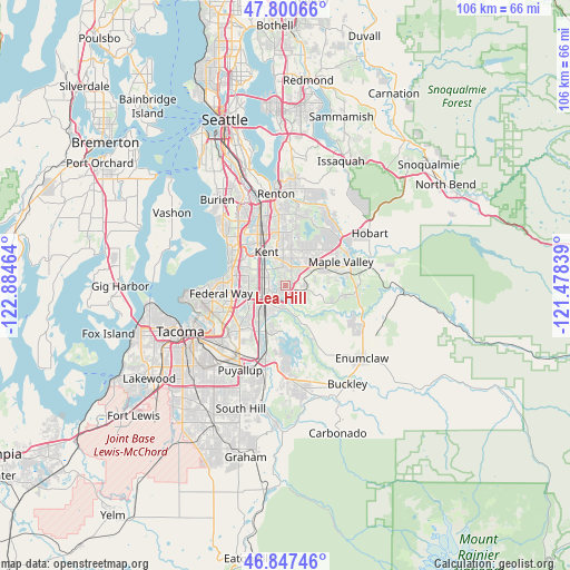
Lea Hill GPS coordinates[2]
47° 19' 34.356" North, 122° 10' 53.436" West
| Map corner | latitude | longitude |
|---|---|---|
| Upper-left | 47.80066°, | -122.88464° |
| Center: | 47.32621°, | -122.18151° |
| Lower-right: | 46.84746°, | -121.47839° |
| Map W x H: | 106×106 km | = 65.9×65.9mi |
| max Lat: | 71.29058° ⇑2.8% North |
| Lea Hill: | 47.32621° |
| min Lat: | ⇓97.2% South 19.06759° |
| min Long | Lea Hill | max Long |
| -171.73463° | -122.18151° | -66.98998° |
| W 4.4%⇐ | ⇒95.6% E |
Elevation
Elevation of Lea Hill is 128 m = 420 ft, and this is 166.8 m = 547 ft below average elevation for this country.
| Max E: |
3189 m = 10463 ft | 65% |
| Avg. | 294.8 m = 967 ft | |
| Lea Hill | 128 m = 420 ft | |
Min E: |
-60 m = -197 ft | 35% |
See also: United States elevation on elevation.city.
Geographical zone
Lea Hill is located in North temperate zone (between Tropic of Cancer and the Arctic Circle). Distance of this North polar circle is 2139 km =1329.1 mi to North.| Distance of | km | miles | from Lea Hill |
|---|---|---|---|
| North Pole | 4744.9 | 2948.3 | to North |
| Arctic Circle | 2139 | 1329.1 | to North |
| Tropic Cancer | 2656.3 | 1650.5 | to South |
| Equator | 5262.2 | 3269.8 | to South |


Nearby cities:
15 places around Lea Hill: (largest is in red/bold)
• Algona
7.5 km =4.7 mi,  225°
225°
• Auburn
4.1 km =2.5 mi,  239°
239°
• Black Diamond
13.6 km =8.5 mi,  98°
98°
• Covington
5.7 km =3.5 mi,  51°
51°
• Des Moines
13.6 km =8.5 mi,  308°
308°
• East Hill-Meridian
9.4 km =5.8 mi,  3°
3°
• Edgewood
12 km =7.5 mi, 225°
• Federal Way
9.9 km =6.2 mi,  267°
267°
• Kent
7.3 km =4.5 mi,  326°
326°
• Lake Morton-Berrydale
6 km =3.7 mi,  83°
83°
• Lakeland North
7.2 km =4.5 mi,  276°
276°
• Lakeland South
9.3 km =5.8 mi, 235°
• Maple Valley
12.6 km =7.8 mi, 53°
• Milton
13.2 km =8.2 mi, 228°
• Pacific
8.6 km =5.3 mi,  217°
217°
Sources, notices
• [Note1] Compared only with cities in United States existing in our database
• [Src1] Map data: © OpenStreetMap contributors (CC-BY-SA)
• [Src2] Other city data from geonames.org with taken over terms of usage.
• [Src3] Geographical zone / Annual Mean Temperature by Robert A. Rohde @ Wikipedia
