Kent geodata
Kent (Washington) is a populated place; located in United States in America/Los_Angeles (GMT-7) time zone. With population of 126,952 people, there are 246 cities with bigger population in this country. Compared to other cities in United States, 97.4% of cities are located further ↓South; 95.7% of cities are located further →East and 91% of cities have higher elevation than Kent. Note1


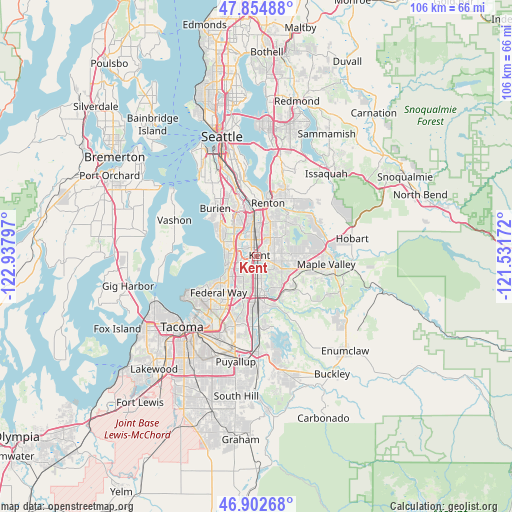
Kent GPS coordinates[2]
47° 22' 51.348" North, 122° 14' 5.424" West
| Map corner | latitude | longitude |
|---|---|---|
| Upper-left | 47.85488°, | -122.93797° |
| Center: | 47.38093°, | -122.23484° |
| Lower-right: | 46.90268°, | -121.53172° |
| Map W x H: | 105.9×105.9 km | = 65.8×65.8mi |
| max Lat: | 71.29058° ⇑2.6% North |
| Kent: | 47.38093° |
| min Lat: | ⇓97.4% South 19.06759° |
| min Long | Kent | max Long |
| -171.73463° | -122.23484° | -66.98998° |
| W 4.3%⇐ | ⇒95.7% E |
Elevation
Elevation of Kent is 14 m = 46 ft, and this is 280.8 m = 921 ft below average elevation for this country.
| Max E: |
3189 m = 10463 ft | 91% |
| Avg. | 294.8 m = 967 ft | |
| Kent | 14 m = 46 ft | |
Min E: |
-60 m = -197 ft | 9% |
See also: Kent elevation on elevation.city.
Geographical zone
Kent is located in North temperate zone (between Tropic of Cancer and the Arctic Circle). Distance of this North polar circle is 2132.9 km =1325.3 mi to North.| Distance of | km | miles | from Kent |
|---|---|---|---|
| North Pole | 4738.8 | 2944.6 | to North |
| Arctic Circle | 2132.9 | 1325.3 | to North |
| Tropic Cancer | 2662.3 | 1654.3 | to South |
| Equator | 5268.3 | 3273.6 | to South |


Nearby cities:
15 places around Kent: (largest is in red/bold)
• Algona
11.4 km =7.1 mi,  186°
186°
• Auburn
8.2 km =5.1 mi,  176°
176°
• Covington
8.9 km =5.5 mi,  106°
106°
• Des Moines
7.1 km =4.4 mi,  288°
288°
• East Hill-Meridian
5.7 km =3.5 mi,  54°
54°
• Fairwood
9.5 km =5.9 mi,  37°
37°
• Federal Way
8.8 km =5.5 mi,  221°
221°
• Lake Morton-Berrydale
11.3 km =7 mi,  118°
118°
• Lakeland North
6.2 km =3.9 mi,  210°
210°
• Lakeland South
12 km =7.5 mi,  197°
197°
• Lea Hill
7.3 km =4.5 mi,  146°
146°
• Normandy Park
10.1 km =6.3 mi,  307°
307°
• Renton
11.4 km =7.1 mi,  6°
6°
• SeaTac
8.7 km =5.4 mi,  330°
330°
• Tukwila
10.5 km =6.5 mi,  349°
349°
Sources, notices
• [Note1] Compared only with cities in United States existing in our database
• [Src1] Map data: © OpenStreetMap contributors (CC-BY-SA)
• [Src2] Other city data from geonames.org with taken over terms of usage.
• [Src3] Geographical zone / Annual Mean Temperature by Robert A. Rohde @ Wikipedia
