Lake Morton-Berrydale geodata
Lake Morton-Berrydale (Washington) is a populated place; located in United States in America/Los_Angeles (GMT-7) time zone. With population of 10,160 people, there are 4415 cities with bigger population in this country. Compared to other cities in United States, 97.3% of cities are located further ↓South; 95.4% of cities are located further →East and 62.6% of cities have higher elevation than Lake Morton-Berrydale. Note1
Current local time in Lake Morton-Berrydale:
12:02 PM, WednesdayDifference from your time zone: hours


Lake Morton-Berrydale GPS coordinates[2]
47° 19' 57.036" North, 122° 6' 10.296" West
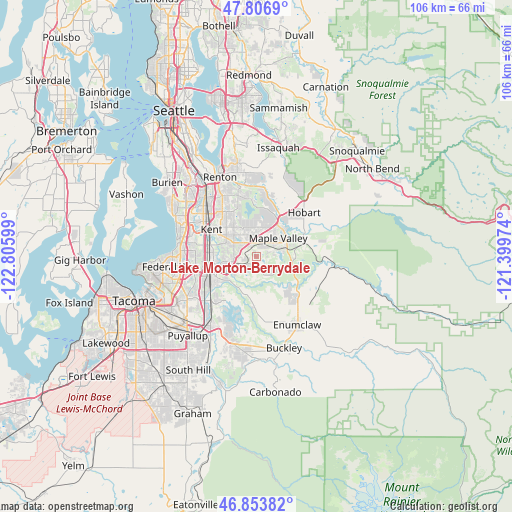
| Map corner | latitude | longitude |
|---|---|---|
| Upper-left | 47.8069°, | -122.80599° |
| Center: | 47.33251°, | -122.10286° |
| Lower-right: | 46.85382°, | -121.39974° |
| Map W x H: | 106×106 km | = 65.9×65.9mi |
| max Lat: | 71.29058° ⇑2.7% North |
| Lake Morton-Berrydale: | 47.33251° |
| min Lat: | ⇓97.3% South 19.06759° |
| min Long | Lake Morton-Ber | max Long |
| -171.73463° | -122.10286° | -66.98998° |
| W 4.6%⇐ | ⇒95.4% E |
Elevation
Elevation of Lake Morton-Berrydale is 141 m = 463 ft, and this is 153.8 m = 505 ft below average elevation for this country.
| Max E: |
3189 m = 10463 ft | 62.6% |
| Avg. | 294.8 m = 967 ft | |
| Lake Morton-Berrydale | 141 m = 463 ft | |
Min E: |
-60 m = -197 ft | 37.4% |
See also: United States elevation on elevation.city.
Geographical zone
Lake Morton-Berrydale is located in North temperate zone (between Tropic of Cancer and the Arctic Circle). Distance of this North polar circle is 2138.3 km =1328.7 mi to North.| Distance of | km | miles | from Lake Morton-Berrydale |
|---|---|---|---|
| North Pole | 4744.2 | 2947.9 | to North |
| Arctic Circle | 2138.3 | 1328.7 | to North |
| Tropic Cancer | 2657 | 1651 | to South |
| Equator | 5262.9 | 3270.2 | to South |


Nearby cities:
15 places around Lake Morton-Berrydale: (largest is in red/bold)
• Algona
12.7 km =7.9 mi,  242°
242°
• Auburn
9.9 km =6.2 mi,  253°
253°
• Black Diamond
8 km =5 mi,  109°
109°
• Covington
3.2 km =2 mi,  333°
333°
• East Hill-Meridian
10.2 km =6.3 mi, 328°
• Fairwood
13.5 km =8.4 mi,  342°
342°
• Hobart
13.9 km =8.6 mi,  44°
44°
• Kent
11.3 km =7 mi,  298°
298°
• Lakeland North
13.1 km =8.1 mi,  270°
270°
• Lakeland South
14.9 km =9.3 mi, 246°
• Lea Hill
6 km =3.7 mi,  263°
263°
• Maple Heights-Lake Desire
12.4 km =7.7 mi,  1°
1°
• Maple Valley
7.9 km =4.9 mi,  32°
32°
• Pacific
13.4 km =8.3 mi, 235°
• Ravensdale
9.2 km =5.7 mi,  76°
76°
Sources, notices
• [Note1] Compared only with cities in United States existing in our database
• [Src1] Map data: © OpenStreetMap contributors (CC-BY-SA)
• [Src2] Other city data from geonames.org with taken over terms of usage.
• [Src3] Geographical zone / Annual Mean Temperature by Robert A. Rohde @ Wikipedia
