Auburn geodata
Auburn (Washington) is a populated place; located in United States in America/Los_Angeles (GMT-7) time zone. With population of 77,006 people, there are 520 cities with bigger population in this country. Compared to other cities in United States, 97.2% of cities are located further ↓South; 95.7% of cities are located further →East and 86.2% of cities have higher elevation than Auburn. Note1


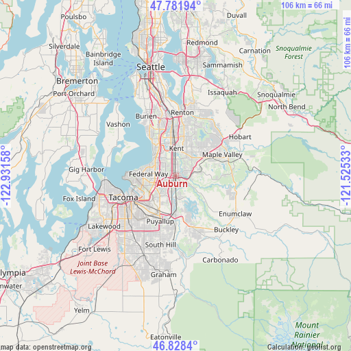
Auburn GPS coordinates[2]
47° 18' 26.352" North, 122° 13' 42.42" West
| Map corner | latitude | longitude |
|---|---|---|
| Upper-left | 47.78194°, | -122.93158° |
| Center: | 47.30732°, | -122.22845° |
| Lower-right: | 46.8284°, | -121.52533° |
| Map W x H: | 106×106 km | = 65.9×65.9mi |
| max Lat: | 71.29058° ⇑2.8% North |
| Auburn: | 47.30732° |
| min Lat: | ⇓97.2% South 19.06759° |
| min Long | Auburn | max Long |
| -171.73463° | -122.22845° | -66.98998° |
| W 4.3%⇐ | ⇒95.7% E |
Elevation
Elevation of Auburn is 25 m = 82 ft, and this is 269.8 m = 885 ft below average elevation for this country.
| Max E: |
3189 m = 10463 ft | 86.2% |
| Avg. | 294.8 m = 967 ft | |
| Auburn | 25 m = 82 ft | |
Min E: |
-60 m = -197 ft | 13.8% |
See also: Auburn elevation on elevation.city.
Geographical zone
Auburn is located in North temperate zone (between Tropic of Cancer and the Arctic Circle). Distance of this North polar circle is 2141.1 km =1330.4 mi to North.| Distance of | km | miles | from Auburn |
|---|---|---|---|
| North Pole | 4747 | 2949.6 | to North |
| Arctic Circle | 2141.1 | 1330.4 | to North |
| Tropic Cancer | 2654.2 | 1649.2 | to South |
| Equator | 5260.1 | 3268.5 | to South |


Nearby cities:
15 places around Auburn: (largest is in red/bold)
• Algona
3.6 km =2.2 mi,  209°
209°
• Covington
9.8 km =6.1 mi,  54°
54°
• East Hill-Meridian
12.2 km =7.6 mi,  19°
19°
• Edgewood
8 km =5 mi,  217°
217°
• Federal Way
6.6 km =4.1 mi,  284°
284°
• Fife Heights
10.3 km =6.4 mi,  238°
238°
• Kent
8.2 km =5.1 mi,  356°
356°
• Lake Morton-Berrydale
9.9 km =6.2 mi,  73°
73°
• Lakeland North
4.7 km =2.9 mi,  308°
308°
• Lakeland South
5.2 km =3.2 mi,  232°
232°
• Lea Hill
4.1 km =2.5 mi,  59°
59°
• Milton
9.2 km =5.7 mi, 224°
• North Puyallup
11.9 km =7.4 mi,  199°
199°
• Pacific
5 km =3.1 mi, 198°
• Sumner
11.6 km =7.2 mi,  184°
184°
Sources, notices
• [Note1] Compared only with cities in United States existing in our database
• [Src1] Map data: © OpenStreetMap contributors (CC-BY-SA)
• [Src2] Other city data from geonames.org with taken over terms of usage.
• [Src3] Geographical zone / Annual Mean Temperature by Robert A. Rohde @ Wikipedia
