Pine Brook Hill geodata
Pine Brook Hill (Colorado) is a populated place; located in United States in America/Denver (GMT-6) time zone. With population of 983 people, there are 16389 cities with bigger population in this country. Compared to other cities in United States, 54.1% of cities are located further ↓South; 83.6% of cities are located further →East and 99% of cities have lower elevation than Pine Brook Hill. Note1


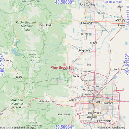
Pine Brook Hill GPS coordinates[2]
40° 2' 59.964" North, 105° 18' 52.956" West
| Map corner | latitude | longitude |
|---|---|---|
| Upper-left | 40.58609°, | -106.01784° |
| Center: | 40.04999°, | -105.31471° |
| Lower-right: | 39.50964°, | -104.61159° |
| Map W x H: | 119.7×119.7 km | = 74.4×74.4mi |
| max Lat: | 71.29058° ⇑45.9% North |
| Pine Brook Hill: | 40.04999° |
| min Lat: | ⇓54.1% South 19.06759° |
| min Long | Pine Brook Hill | max Long |
| -171.73463° | -105.31471° | -66.98998° |
| W 16.4%⇐ | ⇒83.6% E |
Elevation
Elevation of Pine Brook Hill is 1967 m = 6453 ft, and this is 1672.2 m = 5486 ft above average elevation for this country.
| Max E: |
3189 m = 10463 ft | 1% |
| Pine Brook Hill | 1967 m 6453 ft | |
| Avg. | 294.8 m = 967 ft | |
Min E: |
-60 m = -197 ft | 99% |
See also: United States elevation on elevation.city.
Geographical zone
Pine Brook Hill is located in North temperate zone (between Tropic of Cancer and the Arctic Circle). Distance of this Northern Tropic circle is 1847.2 km =1147.8 mi to South.| Distance of | km | miles | from Pine Brook Hill |
|---|---|---|---|
| North Pole | 5553.9 | 3451 | to North |
| Arctic Circle | 2948 | 1831.8 | to North |
| Tropic Cancer | 1847.2 | 1147.8 | to South |
| Equator | 4453.1 | 2767 | to South |


Nearby cities:
15 places around Pine Brook Hill: (largest is in red/bold)
• Altona
9.7 km =6 mi,  16°
16°
• Boulder
5.4 km =3.4 mi,  135°
135°
• Coal Creek
16.8 km =10.4 mi,  198°
198°
• Eldorado Springs
13.5 km =8.4 mi,  166°
166°
• Erie
22.5 km =14 mi,  89°
89°
• Gunbarrel
12.3 km =7.6 mi,  83°
83°
• Lafayette
20.2 km =12.6 mi,  108°
108°
• Lazy Acres
5.1 km =3.2 mi,  342°
342°
• Longmont
22.3 km =13.9 mi,  54°
54°
• Louisville
17.5 km =10.9 mi,  117°
117°
• Lyons
19.8 km =12.3 mi,  10°
10°
• Nederland
19.4 km =12.1 mi,  239°
239°
• Niwot
13.6 km =8.5 mi,  63°
63°
• Paragon Estates
14.1 km =8.8 mi, 122°
• Superior
16.5 km =10.3 mi,  130°
130°
Sources, notices
• [Note1] Compared only with cities in United States existing in our database
• [Src1] Map data: © OpenStreetMap contributors (CC-BY-SA)
• [Src2] Other city data from geonames.org with taken over terms of usage.
• [Src3] Geographical zone / Annual Mean Temperature by Robert A. Rohde @ Wikipedia
