Estes Park geodata
Estes Park (Colorado) is a populated place; located in United States in America/Denver (GMT-6) time zone. With population of 6,257 people, there are 6238 cities with bigger population in this country. Compared to other cities in United States, 57.6% of cities are located further ↓South; 83.7% of cities are located further →East and 99.7% of cities have lower elevation than Estes Park. Note1


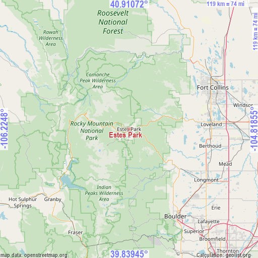
Estes Park GPS coordinates[2]
40° 22' 37.956" North, 105° 31' 18.012" West
| Map corner | latitude | longitude |
|---|---|---|
| Upper-left | 40.91072°, | -106.2248° |
| Center: | 40.37721°, | -105.52167° |
| Lower-right: | 39.83945°, | -104.81855° |
| Map W x H: | 119.1×119.1 km | = 74×74mi |
| max Lat: | 71.29058° ⇑42.4% North |
| Estes Park: | 40.37721° |
| min Lat: | ⇓57.6% South 19.06759° |
| min Long | Estes Park | max Long |
| -171.73463° | -105.52167° | -66.98998° |
| W 16.3%⇐ | ⇒83.7% E |
Elevation
Elevation of Estes Park is 2302 m = 7552 ft, and this is 2007.2 m = 6585 ft above average elevation for this country.
| Max E: |
3189 m = 10463 ft | 0.3% |
| Estes Park | 2302 m 7552 ft | |
| Avg. | 294.8 m = 967 ft | |
Min E: |
-60 m = -197 ft | 99.7% |
See also: United States elevation on elevation.city.
Geographical zone
Estes Park is located in North temperate zone (between Tropic of Cancer and the Arctic Circle). Distance of this Northern Tropic circle is 1883.6 km =1170.4 mi to South.| Distance of | km | miles | from Estes Park |
|---|---|---|---|
| North Pole | 5517.5 | 3428.4 | to North |
| Arctic Circle | 2911.6 | 1809.2 | to North |
| Tropic Cancer | 1883.6 | 1170.4 | to South |
| Equator | 4489.5 | 2789.6 | to South |


Nearby cities:
15 places around Estes Park: (largest is in red/bold)
• Allenspark
20.3 km =12.6 mi,  180°
180°
• Altona
33.8 km =21 mi,  143°
143°
• Berthoud
38.1 km =23.7 mi,  101°
101°
• Boulder
45.6 km =28.3 mi,  152°
152°
• Campion
37.7 km =23.4 mi,  94°
94°
• Fort Collins
43.6 km =27.1 mi,  57°
57°
• Gunbarrel
45.9 km =28.5 mi, 139°
• Laporte
42.6 km =26.5 mi,  49°
49°
• Lazy Acres
35.4 km =22 mi, 153°
• Longmont
42.6 km =26.5 mi,  123°
123°
• Loveland
37.9 km =23.5 mi, 86°
• Lyons
27.2 km =16.9 mi,  128°
128°
• Nederland
46.2 km =28.7 mi, 178°
• Niwot
42.5 km =26.4 mi, 135°
• Pine Brook Hill
40.4 km =25.1 mi, 154°
Sources, notices
• [Note1] Compared only with cities in United States existing in our database
• [Src1] Map data: © OpenStreetMap contributors (CC-BY-SA)
• [Src2] Other city data from geonames.org with taken over terms of usage.
• [Src3] Geographical zone / Annual Mean Temperature by Robert A. Rohde @ Wikipedia
