Laramie geodata
Laramie (Wyoming) is a seat of a second-order administrative division; located in United States in America/Denver (GMT-6) time zone. With population of 32,158 people, there are 1553 cities with bigger population in this country. Compared to other cities in United States, 68.9% of cities are located further ↓South; 83.7% of cities are located further →East and 99.6% of cities have lower elevation than Laramie. Note1


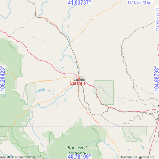
Laramie GPS coordinates[2]
41° 18' 40.932" North, 105° 35' 27.96" West
| Map corner | latitude | longitude |
|---|---|---|
| Upper-left | 41.83737°, | -106.29423° |
| Center: | 41.31137°, | -105.5911° |
| Lower-right: | 40.78109°, | -104.88798° |
| Map W x H: | 117.4×117.4 km | = 72.9×72.9mi |
| max Lat: | 71.29058° ⇑31.1% North |
| Laramie: | 41.31137° |
| min Lat: | ⇓68.9% South 19.06759° |
| min Long | Laramie | max Long |
| -171.73463° | -105.5911° | -66.98998° |
| W 16.3%⇐ | ⇒83.7% E |
Elevation
Elevation of Laramie is 2190 m = 7185 ft, and this is 1895.2 m = 6218 ft above average elevation for this country.
| Max E: |
3189 m = 10463 ft | 0.40000000000001% |
| Laramie | 2190 m 7185 ft | |
| Avg. | 294.8 m = 967 ft | |
Min E: |
-60 m = -197 ft | 99.6% |
See also: United States elevation on elevation.city.
Geographical zone
Laramie is located in North temperate zone (between Tropic of Cancer and the Arctic Circle). Distance of this Northern Tropic circle is 1987.5 km =1235 mi to South.| Distance of | km | miles | from Laramie |
|---|---|---|---|
| North Pole | 5413.7 | 3363.9 | to North |
| Arctic Circle | 2807.8 | 1744.7 | to North |
| Tropic Cancer | 1987.5 | 1235 | to South |
| Equator | 4593.4 | 2854.2 | to South |


Nearby cities:
15 places around Laramie: (largest is in red/bold)
• Cheyenne
67.2 km =41.8 mi,  106°
106°
• Estes Park
104 km =64.6 mi,  176°
176°
• Fort Collins
91.3 km =56.7 mi,  152°
152°
• Fox Farm-College
70.9 km =44.1 mi, 108°
• Hanna
101.9 km =63.3 mi,  307°
307°
• Laporte
85.1 km =52.9 mi, 153°
• Pierce
102.8 km =63.9 mi,  136°
136°
• Ranchettes
67.7 km =42.1 mi,  98°
98°
• Saratoga
102.6 km =63.8 mi,  278°
278°
• Severance
107.4 km =66.7 mi, 144°
• South Greeley
69.8 km =43.4 mi, 109°
• Timnath
100.8 km =62.6 mi, 149°
• Walden
86.8 km =53.9 mi,  222°
222°
• Wellington
83.4 km =51.8 mi, 144°
• Wheatland
98.1 km =61 mi,  32°
32°
Sources, notices
• [Note1] Compared only with cities in United States existing in our database
• [Src1] Map data: © OpenStreetMap contributors (CC-BY-SA)
• [Src2] Other city data from geonames.org with taken over terms of usage.
• [Src3] Geographical zone / Annual Mean Temperature by Robert A. Rohde @ Wikipedia
