Boise geodata
Boise (Idaho) is a seat of a first-order administrative division; located in United States in America/Boise (GMT-6) time zone. With population of 145,987 people, there are 205 cities with bigger population in this country. Compared to other cities in United States, 86.8% of cities are located further ↓South; 89.2% of cities are located further →East and 92.3% of cities have lower elevation than Boise. Note1


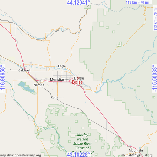
Boise GPS coordinates[2]
43° 36' 48.6" North, 116° 12' 12.42" West
| Map corner | latitude | longitude |
|---|---|---|
| Upper-left | 44.12041°, | -116.90658° |
| Center: | 43.6135°, | -116.20345° |
| Lower-right: | 43.10228°, | -115.50033° |
| Map W x H: | 113.2×113.2 km | = 70.3×70.3mi |
| max Lat: | 71.29058° ⇑13.2% North |
| Boise: | 43.6135° |
| min Lat: | ⇓86.8% South 19.06759° |
| min Long | Boise | max Long |
| -171.73463° | -116.20345° | -66.98998° |
| W 10.8%⇐ | ⇒89.2% E |
Elevation
Elevation of Boise is 834 m = 2736 ft, and this is 539.2 m = 1769 ft above average elevation for this country.
| Max E: |
3189 m = 10463 ft | 7.7% |
| Boise | 834 m 2736 ft | |
| Avg. | 294.8 m = 967 ft | |
Min E: |
-60 m = -197 ft | 92.3% |
See also: Boise elevation on elevation.city.
Geographical zone
Boise is located in North temperate zone (between Tropic of Cancer and the Arctic Circle). Distance of this Northern Tropic circle is 2243.4 km =1394 mi to South.| Distance of | km | miles | from Boise |
|---|---|---|---|
| North Pole | 5157.7 | 3204.8 | to North |
| Arctic Circle | 2551.8 | 1585.6 | to North |
| Tropic Cancer | 2243.4 | 1394 | to South |
| Equator | 4849.4 | 3013.3 | to South |


Nearby cities:
15 places around Boise: (largest is in red/bold)
• Caldwell
39.3 km =24.4 mi,  278°
278°
• Eagle
15.2 km =9.4 mi,  306°
306°
• Emmett
37.4 km =23.2 mi,  320°
320°
• Garden City
3 km =1.9 mi,  288°
288°
• Greenleaf
49.7 km =30.9 mi, 277°
• Hidden Spring
12.7 km =7.9 mi,  342°
342°
• Horseshoe Bend
33.5 km =20.8 mi,  0°
0°
• Idaho City
38.1 km =23.7 mi,  51°
51°
• Kuna
22.1 km =13.7 mi,  232°
232°
• Marsing
49.7 km =30.9 mi,  261°
261°
• Melba
37.3 km =23.2 mi,  224°
224°
• Meridian
15.1 km =9.4 mi,  269°
269°
• Middleton
35.1 km =21.8 mi, 287°
• Nampa
30.1 km =18.7 mi,  254°
254°
• Star
24.9 km =15.5 mi, 290°
Sources, notices
• [Note1] Compared only with cities in United States existing in our database
• [Src1] Map data: © OpenStreetMap contributors (CC-BY-SA)
• [Src2] Other city data from geonames.org with taken over terms of usage.
• [Src3] Geographical zone / Annual Mean Temperature by Robert A. Rohde @ Wikipedia
