Garden City geodata
Garden City (Idaho) is a populated place; located in United States in America/Boise (GMT-6) time zone. With population of 11,550 people, there are 4007 cities with bigger population in this country. Compared to other cities in United States, 86.8% of cities are located further ↓South; 89.2% of cities are located further →East and 92.2% of cities have lower elevation than Garden City. Note1


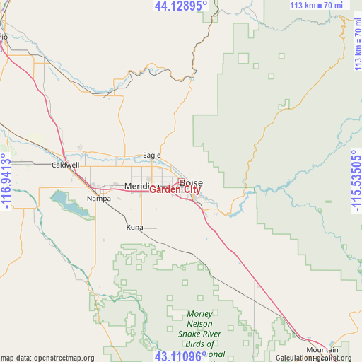
Garden City GPS coordinates[2]
43° 37' 19.596" North, 116° 14' 17.412" West
| Map corner | latitude | longitude |
|---|---|---|
| Upper-left | 44.12895°, | -116.9413° |
| Center: | 43.62211°, | -116.23817° |
| Lower-right: | 43.11096°, | -115.53505° |
| Map W x H: | 113.2×113.2 km | = 70.3×70.3mi |
| max Lat: | 71.29058° ⇑13.2% North |
| Garden City: | 43.62211° |
| min Lat: | ⇓86.8% South 19.06759° |
| min Long | Garden City | max Long |
| -171.73463° | -116.23817° | -66.98998° |
| W 10.8%⇐ | ⇒89.2% E |
Elevation
Elevation of Garden City is 815 m = 2674 ft, and this is 520.2 m = 1707 ft above average elevation for this country.
| Max E: |
3189 m = 10463 ft | 7.8% |
| Garden City | 815 m 2674 ft | |
| Avg. | 294.8 m = 967 ft | |
Min E: |
-60 m = -197 ft | 92.2% |
See also: United States elevation on elevation.city.
Geographical zone
Garden City is located in North temperate zone (between Tropic of Cancer and the Arctic Circle). Distance of this Northern Tropic circle is 2244.4 km =1394.6 mi to South.| Distance of | km | miles | from Garden City |
|---|---|---|---|
| North Pole | 5156.7 | 3204.2 | to North |
| Arctic Circle | 2550.9 | 1585.1 | to North |
| Tropic Cancer | 2244.4 | 1394.6 | to South |
| Equator | 4850.3 | 3013.8 | to South |


Nearby cities:
15 places around Garden City: (largest is in red/bold)
• Boise
3 km =1.9 mi,  108°
108°
• Caldwell
36.4 km =22.6 mi,  277°
277°
• Eagle
12.4 km =7.7 mi,  311°
311°
• Emmett
34.9 km =21.7 mi,  323°
323°
• Greenleaf
46.8 km =29.1 mi, 276°
• Hidden Spring
11.2 km =7 mi,  354°
354°
• Horseshoe Bend
32.7 km =20.3 mi,  5°
5°
• Idaho City
39.7 km =24.7 mi,  54°
54°
• Kuna
20.6 km =12.8 mi,  225°
225°
• Melba
36.1 km =22.4 mi,  220°
220°
• Meridian
12.4 km =7.7 mi,  264°
264°
• Middleton
32.1 km =19.9 mi,  287°
287°
• Nampa
27.7 km =17.2 mi,  250°
250°
• Notus
46.7 km =29 mi, 284°
• Star
22 km =13.7 mi, 290°
Sources, notices
• [Note1] Compared only with cities in United States existing in our database
• [Src1] Map data: © OpenStreetMap contributors (CC-BY-SA)
• [Src2] Other city data from geonames.org with taken over terms of usage.
• [Src3] Geographical zone / Annual Mean Temperature by Robert A. Rohde @ Wikipedia
