Whitehall geodata
Whitehall (Montana) is a populated place; located in United States in America/Denver (GMT-6) time zone. With population of 1,094 people, there are 15708 cities with bigger population in this country. Compared to other cities in United States, 94.9% of cities are located further ↓South; 87.7% of cities are located further →East and 95.4% of cities have lower elevation than Whitehall. Note1


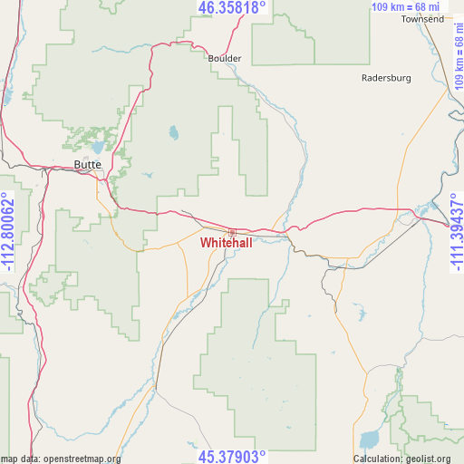
Whitehall GPS coordinates[2]
45° 52' 14.736" North, 112° 5' 50.964" West
| Map corner | latitude | longitude |
|---|---|---|
| Upper-left | 46.35818°, | -112.80062° |
| Center: | 45.87076°, | -112.09749° |
| Lower-right: | 45.37903°, | -111.39437° |
| Map W x H: | 108.9×108.9 km | = 67.7×67.7mi |
| max Lat: | 71.29058° ⇑5.1% North |
| Whitehall: | 45.87076° |
| min Lat: | ⇓94.9% South 19.06759° |
| min Long | Whitehall | max Long |
| -171.73463° | -112.09749° | -66.98998° |
| W 12.3%⇐ | ⇒87.7% E |
Elevation
Elevation of Whitehall is 1330 m = 4364 ft, and this is 1035.2 m = 3396 ft above average elevation for this country.
| Max E: |
3189 m = 10463 ft | 4.6% |
| Whitehall | 1330 m 4364 ft | |
| Avg. | 294.8 m = 967 ft | |
Min E: |
-60 m = -197 ft | 95.4% |
See also: United States elevation on elevation.city.
Geographical zone
Whitehall is located in North temperate zone (between Tropic of Cancer and the Arctic Circle). Distance of this North polar circle is 2300.8 km =1429.7 mi to North.| Distance of | km | miles | from Whitehall |
|---|---|---|---|
| North Pole | 4906.7 | 3048.9 | to North |
| Arctic Circle | 2300.8 | 1429.7 | to North |
| Tropic Cancer | 2494.4 | 1549.9 | to South |
| Equator | 5100.4 | 3169.2 | to South |


Nearby cities:
15 places around Whitehall: (largest is in red/bold)
• Anaconda
71.3 km =44.3 mi,  293°
293°
• Boulder
40.7 km =25.3 mi,  357°
357°
• Butte
36.9 km =22.9 mi, 293°
• Butte-Silver Bow (Balance)
43.4 km =27 mi,  274°
274°
• Churchill
62.9 km =39.1 mi,  102°
102°
• Clancy
66.6 km =41.4 mi,  7°
7°
• Ennis
64.7 km =40.2 mi,  153°
153°
• Manhattan
59.3 km =36.8 mi,  91°
91°
• Sheridan
46.8 km =29.1 mi,  189°
189°
• The Silos
69.8 km =43.4 mi,  34°
34°
• Three Forks
42.3 km =26.3 mi, 86°
• Townsend
66.8 km =41.5 mi,  41°
41°
• Virginia City
65.2 km =40.5 mi,  169°
169°
• Walkerville
38.4 km =23.9 mi,  298°
298°
• Warm Springs
63.3 km =39.3 mi, 303°
Sources, notices
• [Note1] Compared only with cities in United States existing in our database
• [Src1] Map data: © OpenStreetMap contributors (CC-BY-SA)
• [Src2] Other city data from geonames.org with taken over terms of usage.
• [Src3] Geographical zone / Annual Mean Temperature by Robert A. Rohde @ Wikipedia
