Gallatin Gateway geodata
Gallatin Gateway (Montana) is a populated place; located in United States in America/Denver (GMT-6) time zone. With population of 856 people, there are 17325 cities with bigger population in this country. Compared to other cities in United States, 94.3% of cities are located further ↓South; 86.4% of cities are located further →East and 96.7% of cities have lower elevation than Gallatin Gateway. Note1


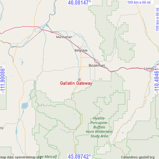
Gallatin Gateway GPS coordinates[2]
45° 35' 29.76" North, 111° 11' 51.828" West
| Map corner | latitude | longitude |
|---|---|---|
| Upper-left | 46.08147°, | -111.90086° |
| Center: | 45.5916°, | -111.19773° |
| Lower-right: | 45.09742°, | -110.49461° |
| Map W x H: | 109.4×109.4 km | = 68×68mi |
| max Lat: | 71.29058° ⇑5.7% North |
| Gallatin Gateway: | 45.5916° |
| min Lat: | ⇓94.3% South 19.06759° |
| min Long | Gallatin Gatewa | max Long |
| -171.73463° | -111.19773° | -66.98998° |
| W 13.6%⇐ | ⇒86.4% E |
Elevation
Elevation of Gallatin Gateway is 1511 m = 4957 ft, and this is 1216.2 m = 3990 ft above average elevation for this country.
| Max E: |
3189 m = 10463 ft | 3.3% |
| Gallatin Gateway | 1511 m 4957 ft | |
| Avg. | 294.8 m = 967 ft | |
Min E: |
-60 m = -197 ft | 96.7% |
See also: United States elevation on elevation.city.
Geographical zone
Gallatin Gateway is located in North temperate zone (between Tropic of Cancer and the Arctic Circle). Distance of this North polar circle is 2331.9 km =1449 mi to North.| Distance of | km | miles | from Gallatin Gateway |
|---|---|---|---|
| North Pole | 4937.8 | 3068.2 | to North |
| Arctic Circle | 2331.9 | 1449 | to North |
| Tropic Cancer | 2463.4 | 1530.7 | to South |
| Equator | 5069.3 | 3149.9 | to South |


Nearby cities:
15 places around Gallatin Gateway: (largest is in red/bold)
• Belgrade
20.6 km =12.8 mi,  4°
4°
• Big Sky
36.6 km =22.7 mi,  201°
201°
• Bozeman
15.8 km =9.8 mi,  51°
51°
• Churchill
19.5 km =12.1 mi,  334°
334°
• Ennis
49.5 km =30.8 mi,  236°
236°
• Four Corners
4.3 km =2.7 mi,  12°
12°
• Gardiner
73.2 km =45.5 mi,  148°
148°
• King Arthur Park
10.2 km =6.3 mi,  34°
34°
• Livingston
50.1 km =31.1 mi,  80°
80°
• Manhattan
31.3 km =19.4 mi,  340°
340°
• Pray
46.6 km =29 mi,  120°
120°
• Sheridan
79.3 km =49.3 mi,  258°
258°
• Three Forks
43.3 km =26.9 mi,  320°
320°
• Virginia City
67.1 km =41.7 mi, 240°
• Whitehall
76.4 km =47.5 mi,  293°
293°
Sources, notices
• [Note1] Compared only with cities in United States existing in our database
• [Src1] Map data: © OpenStreetMap contributors (CC-BY-SA)
• [Src2] Other city data from geonames.org with taken over terms of usage.
• [Src3] Geographical zone / Annual Mean Temperature by Robert A. Rohde @ Wikipedia
