Bozeman geodata
Bozeman (Montana) is a seat of a second-order administrative division; located in United States in America/Denver (GMT-6) time zone. With population of 43,405 people, there are 1099 cities with bigger population in this country. Compared to other cities in United States, 94.5% of cities are located further ↓South; 86.3% of cities are located further →East and 96.5% of cities have lower elevation than Bozeman. Note1


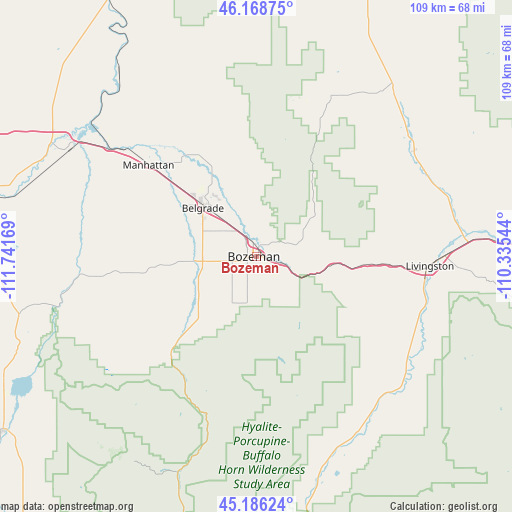
Bozeman GPS coordinates[2]
45° 40' 46.74" North, 111° 2' 18.816" West
| Map corner | latitude | longitude |
|---|---|---|
| Upper-left | 46.16875°, | -111.74169° |
| Center: | 45.67965°, | -111.03856° |
| Lower-right: | 45.18624°, | -110.33544° |
| Map W x H: | 109.2×109.2 km | = 67.9×67.9mi |
| max Lat: | 71.29058° ⇑5.5% North |
| Bozeman: | 45.67965° |
| min Lat: | ⇓94.5% South 19.06759° |
| min Long | Bozeman | max Long |
| -171.73463° | -111.03856° | -66.98998° |
| W 13.7%⇐ | ⇒86.3% E |
Elevation
Elevation of Bozeman is 1469 m = 4820 ft, and this is 1174.2 m = 3852 ft above average elevation for this country.
| Max E: |
3189 m = 10463 ft | 3.5% |
| Bozeman | 1469 m 4820 ft | |
| Avg. | 294.8 m = 967 ft | |
Min E: |
-60 m = -197 ft | 96.5% |
See also: Bozeman elevation on elevation.city.
Geographical zone
Bozeman is located in North temperate zone (between Tropic of Cancer and the Arctic Circle). Distance of this North polar circle is 2322.1 km =1442.9 mi to North.| Distance of | km | miles | from Bozeman |
|---|---|---|---|
| North Pole | 4928 | 3062.1 | to North |
| Arctic Circle | 2322.1 | 1442.9 | to North |
| Tropic Cancer | 2473.2 | 1536.8 | to South |
| Equator | 5079.1 | 3156 | to South |


Nearby cities:
15 places around Bozeman: (largest is in red/bold)
• Belgrade
15.2 km =9.4 mi,  314°
314°
• Big Sky
50.9 km =31.6 mi,  210°
210°
• Churchill
22.1 km =13.7 mi,  290°
290°
• Ennis
65.2 km =40.5 mi,  235°
235°
• Four Corners
12.7 km =7.9 mi, 244°
• Gallatin Gateway
15.8 km =9.8 mi,  231°
231°
• Gardiner
76.6 km =47.6 mi,  160°
160°
• King Arthur Park
6.7 km =4.2 mi,  257°
257°
• Livingston
37.2 km =23.1 mi,  92°
92°
• Manhattan
30.1 km =18.7 mi, 310°
• Pray
43.4 km =27 mi,  140°
140°
• Three Forks
46.3 km =28.8 mi,  300°
300°
• Townsend
80.3 km =49.9 mi,  332°
332°
• Virginia City
82.7 km =51.4 mi, 238°
• Whitehall
84.8 km =52.7 mi,  284°
284°
Sources, notices
• [Note1] Compared only with cities in United States existing in our database
• [Src1] Map data: © OpenStreetMap contributors (CC-BY-SA)
• [Src2] Other city data from geonames.org with taken over terms of usage.
• [Src3] Geographical zone / Annual Mean Temperature by Robert A. Rohde @ Wikipedia
