Seeley Lake geodata
Seeley Lake (Montana) is a populated place; located in United States in America/Denver (GMT-6) time zone. With population of 1,659 people, there are 13052 cities with bigger population in this country. Compared to other cities in United States, 96.9% of cities are located further ↓South; 88.3% of cities are located further →East and 94.7% of cities have lower elevation than Seeley Lake. Note1


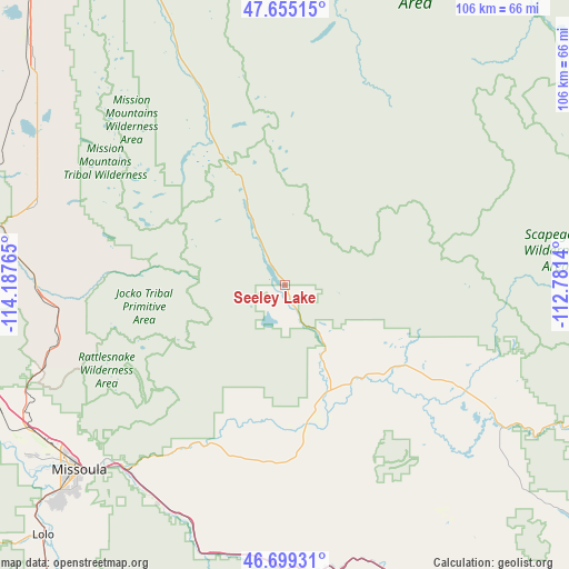
Seeley Lake GPS coordinates[2]
47° 10' 45.768" North, 113° 29' 4.272" West
| Map corner | latitude | longitude |
|---|---|---|
| Upper-left | 47.65515°, | -114.18765° |
| Center: | 47.17938°, | -113.48452° |
| Lower-right: | 46.69931°, | -112.7814° |
| Map W x H: | 106.3×106.3 km | = 66.1×66.1mi |
| max Lat: | 71.29058° ⇑3.1% North |
| Seeley Lake: | 47.17938° |
| min Lat: | ⇓96.9% South 19.06759° |
| min Long | Seeley Lake | max Long |
| -171.73463° | -113.48452° | -66.98998° |
| W 11.7%⇐ | ⇒88.3% E |
Elevation
Elevation of Seeley Lake is 1227 m = 4026 ft, and this is 932.2 m = 3058 ft above average elevation for this country.
| Max E: |
3189 m = 10463 ft | 5.3% |
| Seeley Lake | 1227 m 4026 ft | |
| Avg. | 294.8 m = 967 ft | |
Min E: |
-60 m = -197 ft | 94.7% |
See also: United States elevation on elevation.city.
Geographical zone
Seeley Lake is located in North temperate zone (between Tropic of Cancer and the Arctic Circle). Distance of this North polar circle is 2155.3 km =1339.2 mi to North.| Distance of | km | miles | from Seeley Lake |
|---|---|---|---|
| North Pole | 4761.2 | 2958.5 | to North |
| Arctic Circle | 2155.3 | 1339.2 | to North |
| Tropic Cancer | 2639.9 | 1640.4 | to South |
| Equator | 5245.9 | 3259.7 | to South |


Nearby cities:
15 places around Seeley Lake: (largest is in red/bold)
• Arlee
45.4 km =28.2 mi,  267°
267°
• Bonner-West Riverside
45.4 km =28.2 mi,  222°
222°
• Carlton
71.9 km =44.7 mi, 218°
• Clinton
48.8 km =30.3 mi,  200°
200°
• East Missoula
48.9 km =30.4 mi,  225°
225°
• Florence
75.8 km =47.1 mi, 216°
• Frenchtown
59.3 km =36.8 mi,  252°
252°
• Lincoln
65.7 km =40.8 mi,  112°
112°
• Lolo
65.1 km =40.5 mi, 224°
• Missoula
51.6 km =32.1 mi, 228°
• Orchard Homes
55.3 km =34.4 mi, 230°
• Pablo
66.9 km =41.6 mi,  314°
314°
• Ronan
60.6 km =37.7 mi, 309°
• Saint Ignatius
48.6 km =30.2 mi,  288°
288°
• Wye
54.4 km =33.8 mi,  242°
242°
Sources, notices
• [Note1] Compared only with cities in United States existing in our database
• [Src1] Map data: © OpenStreetMap contributors (CC-BY-SA)
• [Src2] Other city data from geonames.org with taken over terms of usage.
• [Src3] Geographical zone / Annual Mean Temperature by Robert A. Rohde @ Wikipedia
