Manning geodata
Manning (North Dakota) is a seat of a second-order administrative division; located in United States in America/Denver (GMT-6) time zone. With population of 74 people, there are 21046 cities with bigger population in this country. Compared to other cities in United States, 97% of cities are located further ↓South; 82.2% of cities are located further →East and 90.7% of cities have lower elevation than Manning. Note1
Administrative division(s):
- Level 1: North Dakota
- Level 2: Dunn County
- Level 3: Unorganized Territory of Killdeer


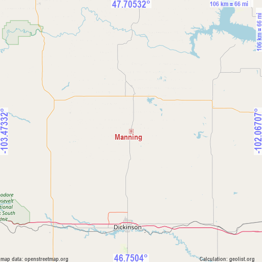
Manning GPS coordinates[2]
47° 13' 48.036" North, 102° 46' 12.684" West
| Map corner | latitude | longitude |
|---|---|---|
| Upper-left | 47.70532°, | -103.47332° |
| Center: | 47.23001°, | -102.77019° |
| Lower-right: | 46.7504°, | -102.06707° |
| Map W x H: | 106.2×106.2 km | = 66×66mi |
| max Lat: | 71.29058° ⇑3% North |
| Manning: | 47.23001° |
| min Lat: | ⇓97% South 19.06759° |
| min Long | Manning | max Long |
| -171.73463° | -102.77019° | -66.98998° |
| W 17.8%⇐ | ⇒82.2% E |
Elevation
Elevation of Manning is 678 m = 2224 ft, and this is 383.2 m = 1257 ft above average elevation for this country.
| Max E: |
3189 m = 10463 ft | 9.3% |
| Manning | 678 m 2224 ft | |
| Avg. | 294.8 m = 967 ft | |
Min E: |
-60 m = -197 ft | 90.7% |
See also: United States elevation on elevation.city.
Geographical zone
Manning is located in North temperate zone (between Tropic of Cancer and the Arctic Circle). Distance of this North polar circle is 2149.7 km =1335.8 mi to North.| Distance of | km | miles | from Manning |
|---|---|---|---|
| North Pole | 4755.6 | 2955 | to North |
| Arctic Circle | 2149.7 | 1335.8 | to North |
| Tropic Cancer | 2645.6 | 1643.9 | to South |
| Equator | 5251.5 | 3263.1 | to South |


Nearby cities:
15 places around Manning: (largest is in red/bold)
• Amidon
93.1 km =57.8 mi,  206°
206°
• Belfield
50.3 km =31.3 mi,  220°
220°
• Beulah
75 km =46.6 mi,  87°
87°
• Dickinson
39 km =24.2 mi,  182°
182°
• Four Bears Village
84.9 km =52.8 mi,  9°
9°
• Glen Ullin
84.9 km =52.8 mi,  122°
122°
• Hazen
86.9 km =54 mi, 85°
• Hebron
66 km =41 mi, 123°
• Killdeer
15.8 km =9.8 mi,  4°
4°
• Mandaree
56 km =34.8 mi, 7°
• Medora
67.1 km =41.7 mi,  238°
238°
• New England
77.2 km =48 mi,  185°
185°
• New Town
86.1 km =53.5 mi, 14°
• Richardton
51.6 km =32.1 mi,  138°
138°
• Watford City
74.4 km =46.2 mi,  328°
328°
Sources, notices
• [Note1] Compared only with cities in United States existing in our database
• [Src1] Map data: © OpenStreetMap contributors (CC-BY-SA)
• [Src2] Other city data from geonames.org with taken over terms of usage.
• [Src3] Geographical zone / Annual Mean Temperature by Robert A. Rohde @ Wikipedia
